ZIP Code 5: 66863 - NEAL, KS
ZIP Code 66863 is the postal code in NEAL, KS. Besides the basic information, it also lists the full ZIP code and the address of ZIP code 66863. Whatsmore, there is more information related to ZIP Code 66863. For example, nearby ZIP code around ZIP Code 66863, etc.
ZIP 66863 Basic Information

The basic information of ZIP Code 66863 is as follows, including: country, county, city, FIPS and etc.
| State | County | City | ZIP Code 5 |
|---|---|---|---|
| KS - Kansas | Greenwood County | NEAL | 66863 |
What is the plus 4 zip code for 66863 ZIP Code? Below is the detail.
66863 ZIP+4 Code List

What are the 4 digit zip extensions of ZIP Code 66863? ZIP code 66863 has many plus 4 codes, and each plus 4 code corresponds to one or more addresses. Below we list all the ZIP+4 codes and their addresses in the ZIP Code 66863. You can find a 9-digit ZIP Code by a full address.
| ZIP Code 5 Plus 4 | Address |
|---|---|
| 66863-0001 | PO BOX 1 (From 1 To 116), NEAL, KS |
| 66863-5073 | 2100 (From 2100 To 2199) SCOMEANC, NEAL, KS |
| 66863-5100 | 2300 (From 2300 To 2399) 140TH ST, NEAL, KS |
| 66863-5101 | 2400 (From 2400 To 2499) 155TH ST, NEAL, KS |
| 66863-5102 | 2400 (From 2400 To 2499) 157TH ST, NEAL, KS |
| 66863-5103 | 2400 (From 2400 To 2499) 158TH ST, NEAL, KS |
| 66863-5104 | 2400 (From 2400 To 2499) US HIGHWAY 54, NEAL, KS |
| 66863-5500 | 1500 (From 1500 To 1599) AA50 RD, NEAL, KS |
| 66863-5501 | 1500 (From 1500 To 1599) AA39 RD, NEAL, KS |
| 66863-5900 | 1500 (From 1500 To 1599) AA20 RD, NEAL, KS |
- Page 1
- ››
Post Office in ZIP Code 66863

NEAL is the only post office in ZIP Code 66863. You can find the address, phone number, and interactive map below. Click to view the service and service hours about NEAL.
-
NEAL Post Office

Address 1567 AA30 RD, NEAL, KS, 66863-9800
Phone 620-637-2776
*Street Parking Available
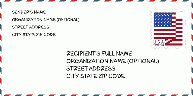
How to write a U.S. envelope?

-
First, you need to fill in the recipient's mailing information in the center of the envelope. The first line is the recipient's name, the second line is the street address with a detailed house number, and the last line is the city, state abbr, and ZIP Code.
Second, write the sender's information on the left top corner of the envelope. If your mail cannot be delivered, it will return to the sender's address.
Finally, don't forget to stick the stamp on the right top corner. Otherwise, the letter will not go into the delivery process.
Here is the envelope example below.
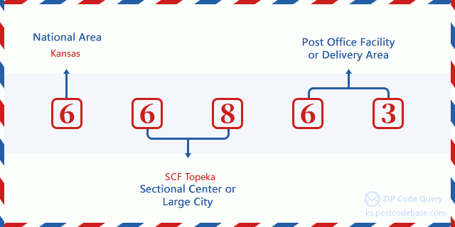
What does each digit of ZIP Code 66863 stand for?
-
The first digit designates a national area, which ranges from zero for the Northeast to nine for the far West.
The 2-3 digits represent a sectional center facility in that region.
The last two digits designate small post offices or postal zones.
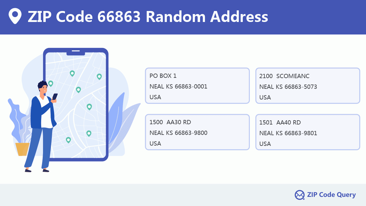
Random Address in ZIP 66863

ZIP Code 66863 has 16 real random addresses, you can clicking the picture below to get random addresses in ZIP Code 66863.
ZIP 66863 Online Map

This is online map of the address NEAL, Greenwood County, Kansas. You may use button to move and zoom in / out. The map information is for reference only.
ZIP 66863 NearBy ZIP Code
The Nearby ZIP Codes are 66870, 66777, 66853, 67137, and 67047, you can find ZIP codes in a 25km radius around ZIP Code 66863 and the approximate distance between the two ZIP codes.
The data has a slight deviation for your reference only.

Comment


Add new comment