Address: 2200 (From 2200 To 2299) DOUGLAS RD, PERRY, KS 66073-5029, USA
What's 66073-5029? 66073-5029 is a ZIP Code 5 Plus 4 number of 2200 (From 2200 To 2299) DOUGLAS RD, PERRY, KS, USA. Below is detail information.
66073-5029 Basic Information

-
ZIP Code 5 Plus 4:
66073-5029 -
ZIP Code 5:
66073 -
Plus 4?50294-digits that are used to identify a geographic segment within the 5-digit delivery area, such as a city block or a group of apartments or an individual high-volume receiver of mail, or any other unit that could use an extra identifier to aid in efficient mail sorting and delivery. This code is the low end of the range of +4 Codes that pertain to this ZIP Code. ZIP+4 Codes associated with nondelivery areas are composed of valid ZIP sector numbers and "ND" for the ZIP segment number, for example 12345-12ND. Non-deliverable areas are areas to which the USPS does not deliver mail, such as vacant lots and land that borders railroad tracks. Mailers should not match an address identified as a nondelivery area. If you absolutely must have numeric characters in the Plus4Code column, you may treat "ND" values as "00" (zero zero).:
-
Country:
U.S. - United States -
State:
KS - Kansas -
County:
CountyFIPS: 20087 - Jefferson County -
City:
PERRY -
Street?DOUGLAS RDThe official name of a street as assigned by a local governing authority. The Street Name column contains only the street name and does not include directionals (EAST, WEST, etc.) or suffixes (ST, DR, BLVD, etc.). This element may also contain literals, such as PO BOX, GENERAL DELIVERY, USS, PSC, or UNIT. Numeric street names that have numeric components that are four characters (or less) in length at are justified such that the low-order digit of the number is positioned in the fourth position of the street name column. This shift is made so that the numeric street names appear in numeric sequence.:
-
Street Suffix?RD (Road)The street suffix: For Example: ST = Street RD = Road DR = Drive LN = Lane:
-
Record Type?S: StreetAn alphabetic value that identifies the type of data in the record. Record type codes include the following: G = General delivery H = Highrise F = Firm S = Street P = PO box R = Rural route/highway contract:
Address

- Address Primary Low Number?
A house, rural route, highway contract box, or post office box number; the numeric or alphanumeric component of an address preceding the street name; the low-end address in a range of addresses. Often referred to as house number.: 2200
- Address Primary High Number?
A house, rural route, contract box, or Post Office box number. The numeric or alphanumeric component of an address preceding the street name. The high-end address in a range of addresses. Often referred to as house number.: 2299
- Address Primary Odd / Even Code?
Code that identifies the side or sides of a street for which a given address range is applicable. For street, highrise, firm and multi-carrier records, B = Both sides of a street, E = Even side of a street (even-numbered addresses in the range); O = Odd side of a street (odd-numbered addresses in the range). For general delivery, post office box, and rural route/highway contract records, this code will always be "B" (both).: Both of Odd and Even
- Primary Range: 2200, 2201, 2202, 2203, 2204, 2205, 2206, 2207, 2208, 2209, 2210, 2211, 2212, 2213, 2214, 2215, 2216, 2217, 2218, 2219, 2220, 2221, 2222, 2223, 2224, 2225, 2226, 2227, 2228, 2229, 2230, 2231, 2232, 2233, 2234, 2235, 2236, 2237, 2238, 2239, 2240, 2241, 2242, 2243, 2244, 2245, 2246, 2247, 2248, 2249, 2250, 2251, 2252, 2253, 2254, 2255, 2256, 2257, 2258, 2259, 2260, 2261, 2262, 2263, 2264, 2265, 2266, 2267, 2268, 2269, 2270, 2271, 2272, 2273, 2274, 2275, 2276, 2277, 2278, 2279, 2280, 2281, 2282, 2283, 2284, 2285, 2286, 2287, 2288, 2289, 2290, 2291, 2292, 2293, 2294, 2295, 2296, 2297, 2298, 2299.
Please click the "More Address Examples" to view the whole list.
2200 DOUGLAS RD, PERRY, KS 66073-5029
2201 DOUGLAS RD, PERRY, KS 66073-5029
2202 DOUGLAS RD, PERRY, KS 66073-5029
2203 DOUGLAS RD, PERRY, KS 66073-5029
2204 DOUGLAS RD, PERRY, KS 66073-5029
2205 DOUGLAS RD, PERRY, KS 66073-5029
2206 DOUGLAS RD, PERRY, KS 66073-5029
2207 DOUGLAS RD, PERRY, KS 66073-5029
2208 DOUGLAS RD, PERRY, KS 66073-5029
2209 DOUGLAS RD, PERRY, KS 66073-5029
2210 DOUGLAS RD, PERRY, KS 66073-5029
2211 DOUGLAS RD, PERRY, KS 66073-5029
2212 DOUGLAS RD, PERRY, KS 66073-5029
2213 DOUGLAS RD, PERRY, KS 66073-5029
2214 DOUGLAS RD, PERRY, KS 66073-5029
2215 DOUGLAS RD, PERRY, KS 66073-5029
2216 DOUGLAS RD, PERRY, KS 66073-5029
2217 DOUGLAS RD, PERRY, KS 66073-5029
2218 DOUGLAS RD, PERRY, KS 66073-5029
2219 DOUGLAS RD, PERRY, KS 66073-5029
2220 DOUGLAS RD, PERRY, KS 66073-5029
2221 DOUGLAS RD, PERRY, KS 66073-5029
2222 DOUGLAS RD, PERRY, KS 66073-5029
2223 DOUGLAS RD, PERRY, KS 66073-5029
2224 DOUGLAS RD, PERRY, KS 66073-5029
2225 DOUGLAS RD, PERRY, KS 66073-5029
2226 DOUGLAS RD, PERRY, KS 66073-5029
2227 DOUGLAS RD, PERRY, KS 66073-5029
2228 DOUGLAS RD, PERRY, KS 66073-5029
2229 DOUGLAS RD, PERRY, KS 66073-5029
2230 DOUGLAS RD, PERRY, KS 66073-5029
2231 DOUGLAS RD, PERRY, KS 66073-5029
2232 DOUGLAS RD, PERRY, KS 66073-5029
2233 DOUGLAS RD, PERRY, KS 66073-5029
2234 DOUGLAS RD, PERRY, KS 66073-5029
2235 DOUGLAS RD, PERRY, KS 66073-5029
2236 DOUGLAS RD, PERRY, KS 66073-5029
2237 DOUGLAS RD, PERRY, KS 66073-5029
2238 DOUGLAS RD, PERRY, KS 66073-5029
2239 DOUGLAS RD, PERRY, KS 66073-5029
2240 DOUGLAS RD, PERRY, KS 66073-5029
2241 DOUGLAS RD, PERRY, KS 66073-5029
2242 DOUGLAS RD, PERRY, KS 66073-5029
2243 DOUGLAS RD, PERRY, KS 66073-5029
2244 DOUGLAS RD, PERRY, KS 66073-5029
2245 DOUGLAS RD, PERRY, KS 66073-5029
2246 DOUGLAS RD, PERRY, KS 66073-5029
2247 DOUGLAS RD, PERRY, KS 66073-5029
2248 DOUGLAS RD, PERRY, KS 66073-5029
2249 DOUGLAS RD, PERRY, KS 66073-5029
2250 DOUGLAS RD, PERRY, KS 66073-5029
2251 DOUGLAS RD, PERRY, KS 66073-5029
2252 DOUGLAS RD, PERRY, KS 66073-5029
2253 DOUGLAS RD, PERRY, KS 66073-5029
2254 DOUGLAS RD, PERRY, KS 66073-5029
2255 DOUGLAS RD, PERRY, KS 66073-5029
2256 DOUGLAS RD, PERRY, KS 66073-5029
2257 DOUGLAS RD, PERRY, KS 66073-5029
2258 DOUGLAS RD, PERRY, KS 66073-5029
2259 DOUGLAS RD, PERRY, KS 66073-5029
2260 DOUGLAS RD, PERRY, KS 66073-5029
2261 DOUGLAS RD, PERRY, KS 66073-5029
2262 DOUGLAS RD, PERRY, KS 66073-5029
2263 DOUGLAS RD, PERRY, KS 66073-5029
2264 DOUGLAS RD, PERRY, KS 66073-5029
2265 DOUGLAS RD, PERRY, KS 66073-5029
2266 DOUGLAS RD, PERRY, KS 66073-5029
2267 DOUGLAS RD, PERRY, KS 66073-5029
2268 DOUGLAS RD, PERRY, KS 66073-5029
2269 DOUGLAS RD, PERRY, KS 66073-5029
2270 DOUGLAS RD, PERRY, KS 66073-5029
2271 DOUGLAS RD, PERRY, KS 66073-5029
2272 DOUGLAS RD, PERRY, KS 66073-5029
2273 DOUGLAS RD, PERRY, KS 66073-5029
2274 DOUGLAS RD, PERRY, KS 66073-5029
2275 DOUGLAS RD, PERRY, KS 66073-5029
2276 DOUGLAS RD, PERRY, KS 66073-5029
2277 DOUGLAS RD, PERRY, KS 66073-5029
2278 DOUGLAS RD, PERRY, KS 66073-5029
2279 DOUGLAS RD, PERRY, KS 66073-5029
2280 DOUGLAS RD, PERRY, KS 66073-5029
2281 DOUGLAS RD, PERRY, KS 66073-5029
2282 DOUGLAS RD, PERRY, KS 66073-5029
2283 DOUGLAS RD, PERRY, KS 66073-5029
2284 DOUGLAS RD, PERRY, KS 66073-5029
2285 DOUGLAS RD, PERRY, KS 66073-5029
2286 DOUGLAS RD, PERRY, KS 66073-5029
2287 DOUGLAS RD, PERRY, KS 66073-5029
2288 DOUGLAS RD, PERRY, KS 66073-5029
2289 DOUGLAS RD, PERRY, KS 66073-5029
2290 DOUGLAS RD, PERRY, KS 66073-5029
2291 DOUGLAS RD, PERRY, KS 66073-5029
2292 DOUGLAS RD, PERRY, KS 66073-5029
2293 DOUGLAS RD, PERRY, KS 66073-5029
2294 DOUGLAS RD, PERRY, KS 66073-5029
2295 DOUGLAS RD, PERRY, KS 66073-5029
2296 DOUGLAS RD, PERRY, KS 66073-5029
2297 DOUGLAS RD, PERRY, KS 66073-5029
2298 DOUGLAS RD, PERRY, KS 66073-5029
2299 DOUGLAS RD, PERRY, KS 66073-5029
Address Example
PERRY KS 66073-5029
UNITED STATES OF AMERICA
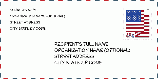
66073-5029 Envelope Example

-
This is an example of U.S envelope. Fill in the sender's information at the top left and the recipient information at the bottom right. The necessary information is sender/recipient's full name, street address, city, state and zip code. The recipient address information has been given for your reference. Generally, If you are not sure of the full 9-digit zip code, you can only fill in the 5-digit zip code to avoid loss of package.
66073-5029 Basic Meaning
-
What does each digit of ZIP Code 66073-5029 stands for? ZIP+4 Code consists of two parts, the first five digits can be located to the post office, and the last four digits can identify a geographic segment within the five-digit delivery area. The 6-7 digits designate sector or several blocks, and the 8-9 digits designate segment or one side of a street.
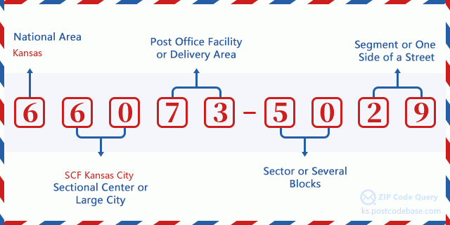

- ·Carrier Route ID?
A 4-digit code assigned to a mail delivery or collection route within a 5-digit ZIP Code. The first character of this identification is alphabetical, and the last three are numeric: Bnnn = PO box Hnnn = Highway contract Rnnn = Rural route Cnnn = City delivery Gnnn = General delivery: R001 (Rural route)
- ·ZIP Add-On Low Sector?
The ZIP Add-On Low Sector and the ZIP Add-On Low Segment together form the ZIP Add-On Low Number. The ZIP Add-On Low Number is the last four positions of a ZIP+4 code; the low-end ZIP add-on in a range of codes; the add-on of the first ZIP+4 code in a consecutive series of ZIP+4 codes assigned to the delivery address. For example, most delivery addresses are assigned a single ZIP+4 code. However, large companies may be given a range of ZIP+4 codes that can be used to route mail to specific departments. A range of ZIP+4 codes can also be assigned to a corresponding range of post office boxes, and each box is mapped, one-to-one, with a ZIP+4 code in the range. A single post office box can also be assigned a range of ZIP+4 codes.: 50
- ·ZIP Add-On Low Segment?
The ZIP Add-On Low Sector and the ZIP Add-On Low Segment together form the ZIP Add-On Low Number. The ZIP Add-On Low Number is the last four positions of a ZIP+4 code; the low-end ZIP add-on in a range of codes; the add-on of the first ZIP+4 code in a consecutive series of ZIP+4 codes assigned to the delivery address. For example, most delivery addresses are assigned a single ZIP+4 code. However, large companies may be given a range of ZIP+4 codes that can be used to route mail to specific departments. A range of ZIP+4 codes can also be assigned to a corresponding range of post office boxes, and each box is mapped, one-to-one, with a ZIP+4 code in the range. A single post office box can also be assigned a range of ZIP+4 codes.: 29
- ·ZIP Add-On High Sector?
The ZIP Add-On High Sector and the ZIP Add-On High Segment together form the ZIP Add-On High Number, which is the high-end ZIP add-on in a range of codes; the add-on of the last ZIP+4 code in a consecutive series of ZIP+4 codes assigned to the delivery address. Most delivery addresses are assigned a single ZIP+4 code; however, large companies may be given a range of ZIP+4 codes that can be used to route mail to specific departments. A range of ZIP+4 codes can also be assigned to a corresponding range of post office boxes, and each box is mapped, one-to-one, with a ZIP+4 code in the range. A single post office box can also be assigned a range of ZIP+4 codes. (See also ZIP Add-On Code.): 50
- ·ZIP Add-On High Segment?
The ZIP Add-On High Sector and the ZIP Add-On High Segment together form the ZIP Add-On High Number, which is the high-end ZIP add-on in a range of codes; the add-on of the last ZIP+4 code in a consecutive series of ZIP+4 codes assigned to the delivery address. Most delivery addresses are assigned a single ZIP+4 code; however, large companies may be given a range of ZIP+4 codes that can be used to route mail to specific departments. A range of ZIP+4 codes can also be assigned to a corresponding range of post office boxes, and each box is mapped, one-to-one, with a ZIP+4 code in the range. A single post office box can also be assigned a range of ZIP+4 codes. (See also ZIP Add-On Code.): 29
- ·ZIP Code Add On: 5029
- ·Range?
The range of +4 codes. Summing the +4 Code and the +4 Range will give you the high end of the range of +4 Codes that pertain to this ZIP Code.: 0
- ·Base Alternate Code?
Code that specifies whether a record is a base (preferred) or alternate record. Base records (represented as "B") can represent a range of addresses or an individual address, such as a firm record, while alternate records (represented as "A") are individual delivery points. Government deliveries will only be listed on alternate records with the appropriate government building indicator (federal, state, or city) set.: Base
- ·Finance Number?
A code assigned to Postal Service facilities (primarily post offices) to collect cost and statistical data and compile revenue and expense data. The state number comprises the first two positions of the finance number.: 197172
- ·Congressional District Number?
A standard value identifying a geographic area within the United States served by a member of the US House of Representatives or Senate. If Army/Air Force (APO) or fleet post office (FPO), this column will be blank. If there is only one member of Congress within a state, the code will be "AL" (at large).: 02
- ·Preferred Last Line City State Key?
An index to the City State file that provides the preferred last-line name for this address range.: W21208
Online Map

This is online map of the address 2200 DOUGLAS RD, PERRY. You may use button to move and zoom in / out. The map information is for reference only.
Address: 2200 (From 2200 To 2299) DOUGLAS RD, PERRY, KS 66073-5029, USA
Comment


Add new comment