Address: 17600 (From 17600 To 17699) SE (Southeast) TEXAS RD, KINCAID, KS 66039-7302, USA
What's 66039-7302? 66039-7302 is a ZIP Code 5 Plus 4 number of 17600 (From 17600 To 17699) SE (Southeast) TEXAS RD, KINCAID, KS, USA. Below is detail information.
66039-7302 Basic Information

-
ZIP Code 5 Plus 4:
66039-7302 -
ZIP Code 5:
66039 -
Plus 4?73024-digits that are used to identify a geographic segment within the 5-digit delivery area, such as a city block or a group of apartments or an individual high-volume receiver of mail, or any other unit that could use an extra identifier to aid in efficient mail sorting and delivery. This code is the low end of the range of +4 Codes that pertain to this ZIP Code. ZIP+4 Codes associated with nondelivery areas are composed of valid ZIP sector numbers and "ND" for the ZIP segment number, for example 12345-12ND. Non-deliverable areas are areas to which the USPS does not deliver mail, such as vacant lots and land that borders railroad tracks. Mailers should not match an address identified as a nondelivery area. If you absolutely must have numeric characters in the Plus4Code column, you may treat "ND" values as "00" (zero zero).:
-
Country:
U.S. - United States -
State:
KS - Kansas -
County:
CountyFIPS: 20003 - Anderson County -
City:
KINCAID -
Street Predirectional:
SE (Southeast) -
Street?TEXAS RDThe official name of a street as assigned by a local governing authority. The Street Name column contains only the street name and does not include directionals (EAST, WEST, etc.) or suffixes (ST, DR, BLVD, etc.). This element may also contain literals, such as PO BOX, GENERAL DELIVERY, USS, PSC, or UNIT. Numeric street names that have numeric components that are four characters (or less) in length at are justified such that the low-order digit of the number is positioned in the fourth position of the street name column. This shift is made so that the numeric street names appear in numeric sequence.:
-
Street Suffix?RD (Road)The street suffix: For Example: ST = Street RD = Road DR = Drive LN = Lane:
-
Record Type?S: StreetAn alphabetic value that identifies the type of data in the record. Record type codes include the following: G = General delivery H = Highrise F = Firm S = Street P = PO box R = Rural route/highway contract:
Address

- Address Primary Low Number?
A house, rural route, highway contract box, or post office box number; the numeric or alphanumeric component of an address preceding the street name; the low-end address in a range of addresses. Often referred to as house number.: 17600
- Address Primary High Number?
A house, rural route, contract box, or Post Office box number. The numeric or alphanumeric component of an address preceding the street name. The high-end address in a range of addresses. Often referred to as house number.: 17699
- Address Primary Odd / Even Code?
Code that identifies the side or sides of a street for which a given address range is applicable. For street, highrise, firm and multi-carrier records, B = Both sides of a street, E = Even side of a street (even-numbered addresses in the range); O = Odd side of a street (odd-numbered addresses in the range). For general delivery, post office box, and rural route/highway contract records, this code will always be "B" (both).: Both of Odd and Even
- Primary Range: 17600, 17601, 17602, 17603, 17604, 17605, 17606, 17607, 17608, 17609, 17610, 17611, 17612, 17613, 17614, 17615, 17616, 17617, 17618, 17619, 17620, 17621, 17622, 17623, 17624, 17625, 17626, 17627, 17628, 17629, 17630, 17631, 17632, 17633, 17634, 17635, 17636, 17637, 17638, 17639, 17640, 17641, 17642, 17643, 17644, 17645, 17646, 17647, 17648, 17649, 17650, 17651, 17652, 17653, 17654, 17655, 17656, 17657, 17658, 17659, 17660, 17661, 17662, 17663, 17664, 17665, 17666, 17667, 17668, 17669, 17670, 17671, 17672, 17673, 17674, 17675, 17676, 17677, 17678, 17679, 17680, 17681, 17682, 17683, 17684, 17685, 17686, 17687, 17688, 17689, 17690, 17691, 17692, 17693, 17694, 17695, 17696, 17697, 17698, 17699.
Please click the "More Address Examples" to view the whole list.
17600 SE (Southeast) TEXAS RD, KINCAID, KS 66039-7302
17601 SE (Southeast) TEXAS RD, KINCAID, KS 66039-7302
17602 SE (Southeast) TEXAS RD, KINCAID, KS 66039-7302
17603 SE (Southeast) TEXAS RD, KINCAID, KS 66039-7302
17604 SE (Southeast) TEXAS RD, KINCAID, KS 66039-7302
17605 SE (Southeast) TEXAS RD, KINCAID, KS 66039-7302
17606 SE (Southeast) TEXAS RD, KINCAID, KS 66039-7302
17607 SE (Southeast) TEXAS RD, KINCAID, KS 66039-7302
17608 SE (Southeast) TEXAS RD, KINCAID, KS 66039-7302
17609 SE (Southeast) TEXAS RD, KINCAID, KS 66039-7302
17610 SE (Southeast) TEXAS RD, KINCAID, KS 66039-7302
17611 SE (Southeast) TEXAS RD, KINCAID, KS 66039-7302
17612 SE (Southeast) TEXAS RD, KINCAID, KS 66039-7302
17613 SE (Southeast) TEXAS RD, KINCAID, KS 66039-7302
17614 SE (Southeast) TEXAS RD, KINCAID, KS 66039-7302
17615 SE (Southeast) TEXAS RD, KINCAID, KS 66039-7302
17616 SE (Southeast) TEXAS RD, KINCAID, KS 66039-7302
17617 SE (Southeast) TEXAS RD, KINCAID, KS 66039-7302
17618 SE (Southeast) TEXAS RD, KINCAID, KS 66039-7302
17619 SE (Southeast) TEXAS RD, KINCAID, KS 66039-7302
17620 SE (Southeast) TEXAS RD, KINCAID, KS 66039-7302
17621 SE (Southeast) TEXAS RD, KINCAID, KS 66039-7302
17622 SE (Southeast) TEXAS RD, KINCAID, KS 66039-7302
17623 SE (Southeast) TEXAS RD, KINCAID, KS 66039-7302
17624 SE (Southeast) TEXAS RD, KINCAID, KS 66039-7302
17625 SE (Southeast) TEXAS RD, KINCAID, KS 66039-7302
17626 SE (Southeast) TEXAS RD, KINCAID, KS 66039-7302
17627 SE (Southeast) TEXAS RD, KINCAID, KS 66039-7302
17628 SE (Southeast) TEXAS RD, KINCAID, KS 66039-7302
17629 SE (Southeast) TEXAS RD, KINCAID, KS 66039-7302
17630 SE (Southeast) TEXAS RD, KINCAID, KS 66039-7302
17631 SE (Southeast) TEXAS RD, KINCAID, KS 66039-7302
17632 SE (Southeast) TEXAS RD, KINCAID, KS 66039-7302
17633 SE (Southeast) TEXAS RD, KINCAID, KS 66039-7302
17634 SE (Southeast) TEXAS RD, KINCAID, KS 66039-7302
17635 SE (Southeast) TEXAS RD, KINCAID, KS 66039-7302
17636 SE (Southeast) TEXAS RD, KINCAID, KS 66039-7302
17637 SE (Southeast) TEXAS RD, KINCAID, KS 66039-7302
17638 SE (Southeast) TEXAS RD, KINCAID, KS 66039-7302
17639 SE (Southeast) TEXAS RD, KINCAID, KS 66039-7302
17640 SE (Southeast) TEXAS RD, KINCAID, KS 66039-7302
17641 SE (Southeast) TEXAS RD, KINCAID, KS 66039-7302
17642 SE (Southeast) TEXAS RD, KINCAID, KS 66039-7302
17643 SE (Southeast) TEXAS RD, KINCAID, KS 66039-7302
17644 SE (Southeast) TEXAS RD, KINCAID, KS 66039-7302
17645 SE (Southeast) TEXAS RD, KINCAID, KS 66039-7302
17646 SE (Southeast) TEXAS RD, KINCAID, KS 66039-7302
17647 SE (Southeast) TEXAS RD, KINCAID, KS 66039-7302
17648 SE (Southeast) TEXAS RD, KINCAID, KS 66039-7302
17649 SE (Southeast) TEXAS RD, KINCAID, KS 66039-7302
17650 SE (Southeast) TEXAS RD, KINCAID, KS 66039-7302
17651 SE (Southeast) TEXAS RD, KINCAID, KS 66039-7302
17652 SE (Southeast) TEXAS RD, KINCAID, KS 66039-7302
17653 SE (Southeast) TEXAS RD, KINCAID, KS 66039-7302
17654 SE (Southeast) TEXAS RD, KINCAID, KS 66039-7302
17655 SE (Southeast) TEXAS RD, KINCAID, KS 66039-7302
17656 SE (Southeast) TEXAS RD, KINCAID, KS 66039-7302
17657 SE (Southeast) TEXAS RD, KINCAID, KS 66039-7302
17658 SE (Southeast) TEXAS RD, KINCAID, KS 66039-7302
17659 SE (Southeast) TEXAS RD, KINCAID, KS 66039-7302
17660 SE (Southeast) TEXAS RD, KINCAID, KS 66039-7302
17661 SE (Southeast) TEXAS RD, KINCAID, KS 66039-7302
17662 SE (Southeast) TEXAS RD, KINCAID, KS 66039-7302
17663 SE (Southeast) TEXAS RD, KINCAID, KS 66039-7302
17664 SE (Southeast) TEXAS RD, KINCAID, KS 66039-7302
17665 SE (Southeast) TEXAS RD, KINCAID, KS 66039-7302
17666 SE (Southeast) TEXAS RD, KINCAID, KS 66039-7302
17667 SE (Southeast) TEXAS RD, KINCAID, KS 66039-7302
17668 SE (Southeast) TEXAS RD, KINCAID, KS 66039-7302
17669 SE (Southeast) TEXAS RD, KINCAID, KS 66039-7302
17670 SE (Southeast) TEXAS RD, KINCAID, KS 66039-7302
17671 SE (Southeast) TEXAS RD, KINCAID, KS 66039-7302
17672 SE (Southeast) TEXAS RD, KINCAID, KS 66039-7302
17673 SE (Southeast) TEXAS RD, KINCAID, KS 66039-7302
17674 SE (Southeast) TEXAS RD, KINCAID, KS 66039-7302
17675 SE (Southeast) TEXAS RD, KINCAID, KS 66039-7302
17676 SE (Southeast) TEXAS RD, KINCAID, KS 66039-7302
17677 SE (Southeast) TEXAS RD, KINCAID, KS 66039-7302
17678 SE (Southeast) TEXAS RD, KINCAID, KS 66039-7302
17679 SE (Southeast) TEXAS RD, KINCAID, KS 66039-7302
17680 SE (Southeast) TEXAS RD, KINCAID, KS 66039-7302
17681 SE (Southeast) TEXAS RD, KINCAID, KS 66039-7302
17682 SE (Southeast) TEXAS RD, KINCAID, KS 66039-7302
17683 SE (Southeast) TEXAS RD, KINCAID, KS 66039-7302
17684 SE (Southeast) TEXAS RD, KINCAID, KS 66039-7302
17685 SE (Southeast) TEXAS RD, KINCAID, KS 66039-7302
17686 SE (Southeast) TEXAS RD, KINCAID, KS 66039-7302
17687 SE (Southeast) TEXAS RD, KINCAID, KS 66039-7302
17688 SE (Southeast) TEXAS RD, KINCAID, KS 66039-7302
17689 SE (Southeast) TEXAS RD, KINCAID, KS 66039-7302
17690 SE (Southeast) TEXAS RD, KINCAID, KS 66039-7302
17691 SE (Southeast) TEXAS RD, KINCAID, KS 66039-7302
17692 SE (Southeast) TEXAS RD, KINCAID, KS 66039-7302
17693 SE (Southeast) TEXAS RD, KINCAID, KS 66039-7302
17694 SE (Southeast) TEXAS RD, KINCAID, KS 66039-7302
17695 SE (Southeast) TEXAS RD, KINCAID, KS 66039-7302
17696 SE (Southeast) TEXAS RD, KINCAID, KS 66039-7302
17697 SE (Southeast) TEXAS RD, KINCAID, KS 66039-7302
17698 SE (Southeast) TEXAS RD, KINCAID, KS 66039-7302
17699 SE (Southeast) TEXAS RD, KINCAID, KS 66039-7302
Address Example
KINCAID KS 66039-7302
UNITED STATES OF AMERICA
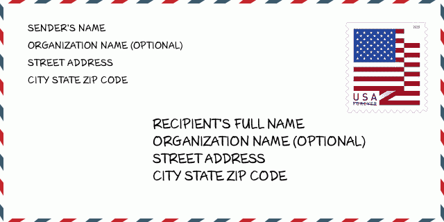
66039-7302 Envelope Example

-
This is an example of U.S envelope. Fill in the sender's information at the top left and the recipient information at the bottom right. The necessary information is sender/recipient's full name, street address, city, state and zip code. The recipient address information has been given for your reference. Generally, If you are not sure of the full 9-digit zip code, you can only fill in the 5-digit zip code to avoid loss of package.
66039-7302 Basic Meaning
-
What does each digit of ZIP Code 66039-7302 stands for? ZIP+4 Code consists of two parts, the first five digits can be located to the post office, and the last four digits can identify a geographic segment within the five-digit delivery area. The 6-7 digits designate sector or several blocks, and the 8-9 digits designate segment or one side of a street.
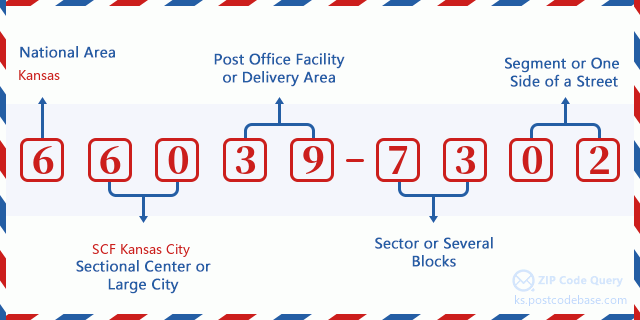

- ·Carrier Route ID?
A 4-digit code assigned to a mail delivery or collection route within a 5-digit ZIP Code. The first character of this identification is alphabetical, and the last three are numeric: Bnnn = PO box Hnnn = Highway contract Rnnn = Rural route Cnnn = City delivery Gnnn = General delivery: R062 (Rural route)
- ·ZIP Add-On Low Sector?
The ZIP Add-On Low Sector and the ZIP Add-On Low Segment together form the ZIP Add-On Low Number. The ZIP Add-On Low Number is the last four positions of a ZIP+4 code; the low-end ZIP add-on in a range of codes; the add-on of the first ZIP+4 code in a consecutive series of ZIP+4 codes assigned to the delivery address. For example, most delivery addresses are assigned a single ZIP+4 code. However, large companies may be given a range of ZIP+4 codes that can be used to route mail to specific departments. A range of ZIP+4 codes can also be assigned to a corresponding range of post office boxes, and each box is mapped, one-to-one, with a ZIP+4 code in the range. A single post office box can also be assigned a range of ZIP+4 codes.: 73
- ·ZIP Add-On Low Segment?
The ZIP Add-On Low Sector and the ZIP Add-On Low Segment together form the ZIP Add-On Low Number. The ZIP Add-On Low Number is the last four positions of a ZIP+4 code; the low-end ZIP add-on in a range of codes; the add-on of the first ZIP+4 code in a consecutive series of ZIP+4 codes assigned to the delivery address. For example, most delivery addresses are assigned a single ZIP+4 code. However, large companies may be given a range of ZIP+4 codes that can be used to route mail to specific departments. A range of ZIP+4 codes can also be assigned to a corresponding range of post office boxes, and each box is mapped, one-to-one, with a ZIP+4 code in the range. A single post office box can also be assigned a range of ZIP+4 codes.: 02
- ·ZIP Add-On High Sector?
The ZIP Add-On High Sector and the ZIP Add-On High Segment together form the ZIP Add-On High Number, which is the high-end ZIP add-on in a range of codes; the add-on of the last ZIP+4 code in a consecutive series of ZIP+4 codes assigned to the delivery address. Most delivery addresses are assigned a single ZIP+4 code; however, large companies may be given a range of ZIP+4 codes that can be used to route mail to specific departments. A range of ZIP+4 codes can also be assigned to a corresponding range of post office boxes, and each box is mapped, one-to-one, with a ZIP+4 code in the range. A single post office box can also be assigned a range of ZIP+4 codes. (See also ZIP Add-On Code.): 73
- ·ZIP Add-On High Segment?
The ZIP Add-On High Sector and the ZIP Add-On High Segment together form the ZIP Add-On High Number, which is the high-end ZIP add-on in a range of codes; the add-on of the last ZIP+4 code in a consecutive series of ZIP+4 codes assigned to the delivery address. Most delivery addresses are assigned a single ZIP+4 code; however, large companies may be given a range of ZIP+4 codes that can be used to route mail to specific departments. A range of ZIP+4 codes can also be assigned to a corresponding range of post office boxes, and each box is mapped, one-to-one, with a ZIP+4 code in the range. A single post office box can also be assigned a range of ZIP+4 codes. (See also ZIP Add-On Code.): 02
- ·ZIP Code Add On: 7302
- ·Range?
The range of +4 codes. Summing the +4 Code and the +4 Range will give you the high end of the range of +4 Codes that pertain to this ZIP Code.: 0
- ·Base Alternate Code?
Code that specifies whether a record is a base (preferred) or alternate record. Base records (represented as "B") can represent a range of addresses or an individual address, such as a firm record, while alternate records (represented as "A") are individual delivery points. Government deliveries will only be listed on alternate records with the appropriate government building indicator (federal, state, or city) set.: Base
- ·Finance Number?
A code assigned to Postal Service facilities (primarily post offices) to collect cost and statistical data and compile revenue and expense data. The state number comprises the first two positions of the finance number.: 194730
- ·Congressional District Number?
A standard value identifying a geographic area within the United States served by a member of the US House of Representatives or Senate. If Army/Air Force (APO) or fleet post office (FPO), this column will be blank. If there is only one member of Congress within a state, the code will be "AL" (at large).: 02
- ·Preferred Last Line City State Key?
An index to the City State file that provides the preferred last-line name for this address range.: W20806
Online Map

This is online map of the address 17600 SE (Southeast) TEXAS RD, KINCAID. You may use button to move and zoom in / out. The map information is for reference only.
Address: 17600 (From 17600 To 17699) SE (Southeast) TEXAS RD, KINCAID, KS 66039-7302, USA
Comment


Add new comment