Address: 400 (From 400 To 499) PAWNEE RD, ATCHISON, KS 66002-5027, USA
What's 66002-5027? 66002-5027 is a ZIP Code 5 Plus 4 number of 400 (From 400 To 499) PAWNEE RD, ATCHISON, KS, USA. Below is detail information.
66002-5027 Basic Information

-
ZIP Code 5 Plus 4:
66002-5027 -
ZIP Code 5:
66002 -
Plus 4?50274-digits that are used to identify a geographic segment within the 5-digit delivery area, such as a city block or a group of apartments or an individual high-volume receiver of mail, or any other unit that could use an extra identifier to aid in efficient mail sorting and delivery. This code is the low end of the range of +4 Codes that pertain to this ZIP Code. ZIP+4 Codes associated with nondelivery areas are composed of valid ZIP sector numbers and "ND" for the ZIP segment number, for example 12345-12ND. Non-deliverable areas are areas to which the USPS does not deliver mail, such as vacant lots and land that borders railroad tracks. Mailers should not match an address identified as a nondelivery area. If you absolutely must have numeric characters in the Plus4Code column, you may treat "ND" values as "00" (zero zero).:
-
Country:
U.S. - United States -
State:
KS - Kansas -
County:
CountyFIPS: 20005 - Atchison County -
City:
ATCHISON -
Street?PAWNEE RDThe official name of a street as assigned by a local governing authority. The Street Name column contains only the street name and does not include directionals (EAST, WEST, etc.) or suffixes (ST, DR, BLVD, etc.). This element may also contain literals, such as PO BOX, GENERAL DELIVERY, USS, PSC, or UNIT. Numeric street names that have numeric components that are four characters (or less) in length at are justified such that the low-order digit of the number is positioned in the fourth position of the street name column. This shift is made so that the numeric street names appear in numeric sequence.:
-
Street Suffix?RD (Road)The street suffix: For Example: ST = Street RD = Road DR = Drive LN = Lane:
-
Record Type?S: StreetAn alphabetic value that identifies the type of data in the record. Record type codes include the following: G = General delivery H = Highrise F = Firm S = Street P = PO box R = Rural route/highway contract:
Address

- Address Primary Low Number?
A house, rural route, highway contract box, or post office box number; the numeric or alphanumeric component of an address preceding the street name; the low-end address in a range of addresses. Often referred to as house number.: 400
- Address Primary High Number?
A house, rural route, contract box, or Post Office box number. The numeric or alphanumeric component of an address preceding the street name. The high-end address in a range of addresses. Often referred to as house number.: 499
- Address Primary Odd / Even Code?
Code that identifies the side or sides of a street for which a given address range is applicable. For street, highrise, firm and multi-carrier records, B = Both sides of a street, E = Even side of a street (even-numbered addresses in the range); O = Odd side of a street (odd-numbered addresses in the range). For general delivery, post office box, and rural route/highway contract records, this code will always be "B" (both).: Both of Odd and Even
- Primary Range: 400, 401, 402, 403, 404, 405, 406, 407, 408, 409, 410, 411, 412, 413, 414, 415, 416, 417, 418, 419, 420, 421, 422, 423, 424, 425, 426, 427, 428, 429, 430, 431, 432, 433, 434, 435, 436, 437, 438, 439, 440, 441, 442, 443, 444, 445, 446, 447, 448, 449, 450, 451, 452, 453, 454, 455, 456, 457, 458, 459, 460, 461, 462, 463, 464, 465, 466, 467, 468, 469, 470, 471, 472, 473, 474, 475, 476, 477, 478, 479, 480, 481, 482, 483, 484, 485, 486, 487, 488, 489, 490, 491, 492, 493, 494, 495, 496, 497, 498, 499.
Please click the "More Address Examples" to view the whole list.
400 PAWNEE RD, ATCHISON, KS 66002-5027
401 PAWNEE RD, ATCHISON, KS 66002-5027
402 PAWNEE RD, ATCHISON, KS 66002-5027
403 PAWNEE RD, ATCHISON, KS 66002-5027
404 PAWNEE RD, ATCHISON, KS 66002-5027
405 PAWNEE RD, ATCHISON, KS 66002-5027
406 PAWNEE RD, ATCHISON, KS 66002-5027
407 PAWNEE RD, ATCHISON, KS 66002-5027
408 PAWNEE RD, ATCHISON, KS 66002-5027
409 PAWNEE RD, ATCHISON, KS 66002-5027
410 PAWNEE RD, ATCHISON, KS 66002-5027
411 PAWNEE RD, ATCHISON, KS 66002-5027
412 PAWNEE RD, ATCHISON, KS 66002-5027
413 PAWNEE RD, ATCHISON, KS 66002-5027
414 PAWNEE RD, ATCHISON, KS 66002-5027
415 PAWNEE RD, ATCHISON, KS 66002-5027
416 PAWNEE RD, ATCHISON, KS 66002-5027
417 PAWNEE RD, ATCHISON, KS 66002-5027
418 PAWNEE RD, ATCHISON, KS 66002-5027
419 PAWNEE RD, ATCHISON, KS 66002-5027
420 PAWNEE RD, ATCHISON, KS 66002-5027
421 PAWNEE RD, ATCHISON, KS 66002-5027
422 PAWNEE RD, ATCHISON, KS 66002-5027
423 PAWNEE RD, ATCHISON, KS 66002-5027
424 PAWNEE RD, ATCHISON, KS 66002-5027
425 PAWNEE RD, ATCHISON, KS 66002-5027
426 PAWNEE RD, ATCHISON, KS 66002-5027
427 PAWNEE RD, ATCHISON, KS 66002-5027
428 PAWNEE RD, ATCHISON, KS 66002-5027
429 PAWNEE RD, ATCHISON, KS 66002-5027
430 PAWNEE RD, ATCHISON, KS 66002-5027
431 PAWNEE RD, ATCHISON, KS 66002-5027
432 PAWNEE RD, ATCHISON, KS 66002-5027
433 PAWNEE RD, ATCHISON, KS 66002-5027
434 PAWNEE RD, ATCHISON, KS 66002-5027
435 PAWNEE RD, ATCHISON, KS 66002-5027
436 PAWNEE RD, ATCHISON, KS 66002-5027
437 PAWNEE RD, ATCHISON, KS 66002-5027
438 PAWNEE RD, ATCHISON, KS 66002-5027
439 PAWNEE RD, ATCHISON, KS 66002-5027
440 PAWNEE RD, ATCHISON, KS 66002-5027
441 PAWNEE RD, ATCHISON, KS 66002-5027
442 PAWNEE RD, ATCHISON, KS 66002-5027
443 PAWNEE RD, ATCHISON, KS 66002-5027
444 PAWNEE RD, ATCHISON, KS 66002-5027
445 PAWNEE RD, ATCHISON, KS 66002-5027
446 PAWNEE RD, ATCHISON, KS 66002-5027
447 PAWNEE RD, ATCHISON, KS 66002-5027
448 PAWNEE RD, ATCHISON, KS 66002-5027
449 PAWNEE RD, ATCHISON, KS 66002-5027
450 PAWNEE RD, ATCHISON, KS 66002-5027
451 PAWNEE RD, ATCHISON, KS 66002-5027
452 PAWNEE RD, ATCHISON, KS 66002-5027
453 PAWNEE RD, ATCHISON, KS 66002-5027
454 PAWNEE RD, ATCHISON, KS 66002-5027
455 PAWNEE RD, ATCHISON, KS 66002-5027
456 PAWNEE RD, ATCHISON, KS 66002-5027
457 PAWNEE RD, ATCHISON, KS 66002-5027
458 PAWNEE RD, ATCHISON, KS 66002-5027
459 PAWNEE RD, ATCHISON, KS 66002-5027
460 PAWNEE RD, ATCHISON, KS 66002-5027
461 PAWNEE RD, ATCHISON, KS 66002-5027
462 PAWNEE RD, ATCHISON, KS 66002-5027
463 PAWNEE RD, ATCHISON, KS 66002-5027
464 PAWNEE RD, ATCHISON, KS 66002-5027
465 PAWNEE RD, ATCHISON, KS 66002-5027
466 PAWNEE RD, ATCHISON, KS 66002-5027
467 PAWNEE RD, ATCHISON, KS 66002-5027
468 PAWNEE RD, ATCHISON, KS 66002-5027
469 PAWNEE RD, ATCHISON, KS 66002-5027
470 PAWNEE RD, ATCHISON, KS 66002-5027
471 PAWNEE RD, ATCHISON, KS 66002-5027
472 PAWNEE RD, ATCHISON, KS 66002-5027
473 PAWNEE RD, ATCHISON, KS 66002-5027
474 PAWNEE RD, ATCHISON, KS 66002-5027
475 PAWNEE RD, ATCHISON, KS 66002-5027
476 PAWNEE RD, ATCHISON, KS 66002-5027
477 PAWNEE RD, ATCHISON, KS 66002-5027
478 PAWNEE RD, ATCHISON, KS 66002-5027
479 PAWNEE RD, ATCHISON, KS 66002-5027
480 PAWNEE RD, ATCHISON, KS 66002-5027
481 PAWNEE RD, ATCHISON, KS 66002-5027
482 PAWNEE RD, ATCHISON, KS 66002-5027
483 PAWNEE RD, ATCHISON, KS 66002-5027
484 PAWNEE RD, ATCHISON, KS 66002-5027
485 PAWNEE RD, ATCHISON, KS 66002-5027
486 PAWNEE RD, ATCHISON, KS 66002-5027
487 PAWNEE RD, ATCHISON, KS 66002-5027
488 PAWNEE RD, ATCHISON, KS 66002-5027
489 PAWNEE RD, ATCHISON, KS 66002-5027
490 PAWNEE RD, ATCHISON, KS 66002-5027
491 PAWNEE RD, ATCHISON, KS 66002-5027
492 PAWNEE RD, ATCHISON, KS 66002-5027
493 PAWNEE RD, ATCHISON, KS 66002-5027
494 PAWNEE RD, ATCHISON, KS 66002-5027
495 PAWNEE RD, ATCHISON, KS 66002-5027
496 PAWNEE RD, ATCHISON, KS 66002-5027
497 PAWNEE RD, ATCHISON, KS 66002-5027
498 PAWNEE RD, ATCHISON, KS 66002-5027
499 PAWNEE RD, ATCHISON, KS 66002-5027
Address Example
ATCHISON KS 66002-5027
UNITED STATES OF AMERICA
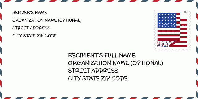
66002-5027 Envelope Example

-
This is an example of U.S envelope. Fill in the sender's information at the top left and the recipient information at the bottom right. The necessary information is sender/recipient's full name, street address, city, state and zip code. The recipient address information has been given for your reference. Generally, If you are not sure of the full 9-digit zip code, you can only fill in the 5-digit zip code to avoid loss of package.
66002-5027 Basic Meaning
-
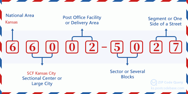
What does each digit of ZIP Code 66002-5027 stands for? ZIP+4 Code consists of two parts, the first five digits can be located to the post office, and the last four digits can identify a geographic segment within the five-digit delivery area. The 6-7 digits designate sector or several blocks, and the 8-9 digits designate segment or one side of a street.

- ·Carrier Route ID?
A 4-digit code assigned to a mail delivery or collection route within a 5-digit ZIP Code. The first character of this identification is alphabetical, and the last three are numeric: Bnnn = PO box Hnnn = Highway contract Rnnn = Rural route Cnnn = City delivery Gnnn = General delivery: R003 (Rural route)
- ·ZIP Add-On Low Sector?
The ZIP Add-On Low Sector and the ZIP Add-On Low Segment together form the ZIP Add-On Low Number. The ZIP Add-On Low Number is the last four positions of a ZIP+4 code; the low-end ZIP add-on in a range of codes; the add-on of the first ZIP+4 code in a consecutive series of ZIP+4 codes assigned to the delivery address. For example, most delivery addresses are assigned a single ZIP+4 code. However, large companies may be given a range of ZIP+4 codes that can be used to route mail to specific departments. A range of ZIP+4 codes can also be assigned to a corresponding range of post office boxes, and each box is mapped, one-to-one, with a ZIP+4 code in the range. A single post office box can also be assigned a range of ZIP+4 codes.: 50
- ·ZIP Add-On Low Segment?
The ZIP Add-On Low Sector and the ZIP Add-On Low Segment together form the ZIP Add-On Low Number. The ZIP Add-On Low Number is the last four positions of a ZIP+4 code; the low-end ZIP add-on in a range of codes; the add-on of the first ZIP+4 code in a consecutive series of ZIP+4 codes assigned to the delivery address. For example, most delivery addresses are assigned a single ZIP+4 code. However, large companies may be given a range of ZIP+4 codes that can be used to route mail to specific departments. A range of ZIP+4 codes can also be assigned to a corresponding range of post office boxes, and each box is mapped, one-to-one, with a ZIP+4 code in the range. A single post office box can also be assigned a range of ZIP+4 codes.: 27
- ·ZIP Add-On High Sector?
The ZIP Add-On High Sector and the ZIP Add-On High Segment together form the ZIP Add-On High Number, which is the high-end ZIP add-on in a range of codes; the add-on of the last ZIP+4 code in a consecutive series of ZIP+4 codes assigned to the delivery address. Most delivery addresses are assigned a single ZIP+4 code; however, large companies may be given a range of ZIP+4 codes that can be used to route mail to specific departments. A range of ZIP+4 codes can also be assigned to a corresponding range of post office boxes, and each box is mapped, one-to-one, with a ZIP+4 code in the range. A single post office box can also be assigned a range of ZIP+4 codes. (See also ZIP Add-On Code.): 50
- ·ZIP Add-On High Segment?
The ZIP Add-On High Sector and the ZIP Add-On High Segment together form the ZIP Add-On High Number, which is the high-end ZIP add-on in a range of codes; the add-on of the last ZIP+4 code in a consecutive series of ZIP+4 codes assigned to the delivery address. Most delivery addresses are assigned a single ZIP+4 code; however, large companies may be given a range of ZIP+4 codes that can be used to route mail to specific departments. A range of ZIP+4 codes can also be assigned to a corresponding range of post office boxes, and each box is mapped, one-to-one, with a ZIP+4 code in the range. A single post office box can also be assigned a range of ZIP+4 codes. (See also ZIP Add-On Code.): 27
- ·ZIP Code Add On: 5027
- ·Range?
The range of +4 codes. Summing the +4 Code and the +4 Range will give you the high end of the range of +4 Codes that pertain to this ZIP Code.: 0
- ·Base Alternate Code?
Code that specifies whether a record is a base (preferred) or alternate record. Base records (represented as "B") can represent a range of addresses or an individual address, such as a firm record, while alternate records (represented as "A") are individual delivery points. Government deliveries will only be listed on alternate records with the appropriate government building indicator (federal, state, or city) set.: Base
- ·Finance Number?
A code assigned to Postal Service facilities (primarily post offices) to collect cost and statistical data and compile revenue and expense data. The state number comprises the first two positions of the finance number.: 190517
- ·Congressional District Number?
A standard value identifying a geographic area within the United States served by a member of the US House of Representatives or Senate. If Army/Air Force (APO) or fleet post office (FPO), this column will be blank. If there is only one member of Congress within a state, the code will be "AL" (at large).: 02
- ·Preferred Last Line City State Key?
An index to the City State file that provides the preferred last-line name for this address range.: W20074
Online Map

This is online map of the address 400 PAWNEE RD, ATCHISON. You may use button to move and zoom in / out. The map information is for reference only.
Address: 400 (From 400 To 499) PAWNEE RD, ATCHISON, KS 66002-5027, USA
Comment


Add new comment