คุณอยู่ที่นี่

ที่อยู่: 111 E (East) KUMP ST, BONNER SPRINGS, KS 66012-1486, USA

66012-1486คืออะไร 66012-1486 เป็นรหัสไปรษณีย์ห้าบวกสี่หลัก 111 E (East) KUMP ST, BONNER SPRINGS, KS, USA มีรายละเอียดดังต่อไปนี้

66012-1486 ข้อมูลพื้นฐาน

img_Postal
  • รหัสไปรษณีย์ 5 พลัส 4:

    66012-1486
  • รหัสไปรษณีย์ 5:

    66012
  • พลัส 4?
    4-digits that are used to identify a geographic segment within the 5-digit delivery area, such as a city block or a group of apartments or an individual high-volume receiver of mail, or any other unit that could use an extra identifier to aid in efficient mail sorting and delivery. This code is the low end of the range of +4 Codes that pertain to this ZIP Code. ZIP+4 Codes associated with nondelivery areas are composed of valid ZIP sector numbers and "ND" for the ZIP segment number, for example 12345-12ND. Non-deliverable areas are areas to which the USPS does not deliver mail, such as vacant lots and land that borders railroad tracks. Mailers should not match an address identified as a nondelivery area. If you absolutely must have numeric characters in the Plus4Code column, you may treat "ND" values as "00" (zero zero).
    :
    1486
  • ประเทศ:

    U.S. - ประเทศสหรัฐอเมริกา
  • รัฐ:

    KS - แคนซัส
  • อำเภอ:

    CountyFIPS: 20209 - Wyandotte County
  • เมือง:

    BONNER SPRINGS
  • ทิศทางตรงหน้าถนน :

    E (East)
  • ถนน?
    The official name of a street as assigned by a local governing authority. The Street Name column contains only the street name and does not include directionals (EAST, WEST, etc.) or suffixes (ST, DR, BLVD, etc.). This element may also contain literals, such as PO BOX, GENERAL DELIVERY, USS, PSC, or UNIT. Numeric street names that have numeric components that are four characters (or less) in length at are justified such that the low-order digit of the number is positioned in the fourth position of the street name column. This shift is made so that the numeric street names appear in numeric sequence.
    :
    KUMP ST
  • คำต่อท้ายถนน ?
    The street suffix: For Example: ST = Street RD = Road DR = Drive LN = Lane
    :
    ST (ถนน)
  • ประเภทระเบียน?
    An alphabetic value that identifies the type of data in the record. Record type codes include the following: G = General delivery H = Highrise F = Firm S = Street P = PO box R = Rural route/highway contract
    :
    H: ขั้นสูง

ที่อยู่

img_region

66012-1486 ตรงกับที่อยู่ต่อไปนี้

รายการที่อยู่สถานะ
111 E (East) KUMP ST APT 505 (From 505 To 614), BONNER SPRINGS, KS 66012-1486, USAถูกต้อง
111 E (East) KUMP ST, BONNER SPRINGS, KS 66012-1486, USAถูกต้อง

ที่อยู่ ตัวอย่าง

img_region
ที่อยู่ประกอบด้วยบรรทัดต่อไปนี้:
111 E (East) KUMP ST
BONNER SPRINGS KS 66012-1486
UNITED STATES OF AMERICA
หรือคุณสามารถตรวจสอบตัวอย่างซองจดหมายด้านล่างสำหรับข้อมูลเพิ่มเติม

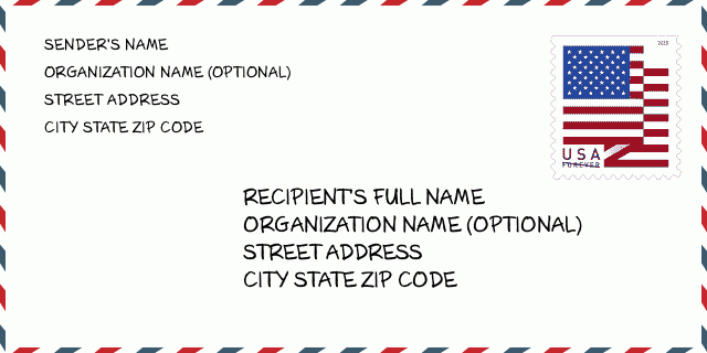
66012-1486 ตัวอย่างซองจดหมาย

img_envelope
  • นี่คือตัวอย่างซองจดหมายของสหรัฐฯ กรอกข้อมูลผู้ส่งที่ด้านบนซ้ายและข้อมูลผู้รับที่ด้านล่างขวา ข้อมูลที่จำเป็นคือชื่อเต็มของผู้ส่ง/ผู้รับ ที่อยู่ เมือง รัฐ และรหัสไปรษณีย์ ข้อมูลที่อยู่ผู้รับได้รับสำหรับการอ้างอิงของคุณ โดยทั่วไป หากคุณไม่แน่ใจเกี่ยวกับรหัสไปรษณีย์ 9 หลักแบบเต็ม คุณสามารถกรอกรหัสไปรษณีย์ 5 หลักเท่านั้นเพื่อหลีกเลี่ยงการสูญหายของพัสดุ

    ZIP Code: 66012-1486

66012-1486 ความหมายพื้นฐาน

img_envelope
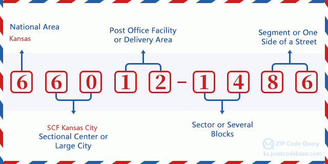
  • รหัสไปรษณีย์ 66012-1486 แต่ละหลักย่อมาจากอะไร ? รหัสไปรษณีย์ประกอบด้วยสองส่วน โดยสามารถระบุหมายเลขห้าหลักแรกไปยังที่ทำการไปรษณีย์ได้ และตัวเลขสี่หลักสุดท้ายสามารถระบุส่วนทางภูมิศาสตร์ภายในพื้นที่จัดส่งห้าหลักได้ ตัวเลข 6-7 หลักกำหนดส่วนหรือหลายช่วงตึก และตัวเลข 8-9 หลักกำหนดส่วนหรือด้านใดด้านหนึ่งของถนน

    ZIP Code: 66012-1486

แผนที่ออนไลน์

แผนที่ออนไลน์

นี่คือแผนที่อิเล็กทรอนิกส์ออนไลน์ที่ที่อยู่ 111 E (East) KUMP ST, BONNER SPRINGSจับคู่นั้น คุณสามารถจะใช้ปุ่มบนแผนที่เพื่อเลื่อนและซูม ข้อมูลแผนที่นี้ เฉพาะสำหรับการอ้างอิงเท่านั้น

ที่อยู่: 111 E (East) KUMP ST, BONNER SPRINGS, KS 66012-1486, USA

ความเห็น

ความเห็น

แสดงความเห็น