ที่อยู่: 1400 (From 1400 To 1499) 95TH RD, ATCHISON, KS 66002-7221, USA
66002-7221คืออะไร 66002-7221 เป็นรหัสไปรษณีย์ห้าบวกสี่หลัก 1400 (From 1400 To 1499) 95TH RD, ATCHISON, KS, USA มีรายละเอียดดังต่อไปนี้
66002-7221 ข้อมูลพื้นฐาน

-
รหัสไปรษณีย์ 5 พลัส 4:
66002-7221 -
รหัสไปรษณีย์ 5:
66002 -
พลัส 4?72214-digits that are used to identify a geographic segment within the 5-digit delivery area, such as a city block or a group of apartments or an individual high-volume receiver of mail, or any other unit that could use an extra identifier to aid in efficient mail sorting and delivery. This code is the low end of the range of +4 Codes that pertain to this ZIP Code. ZIP+4 Codes associated with nondelivery areas are composed of valid ZIP sector numbers and "ND" for the ZIP segment number, for example 12345-12ND. Non-deliverable areas are areas to which the USPS does not deliver mail, such as vacant lots and land that borders railroad tracks. Mailers should not match an address identified as a nondelivery area. If you absolutely must have numeric characters in the Plus4Code column, you may treat "ND" values as "00" (zero zero).:
-
ประเทศ:
U.S. - ประเทศสหรัฐอเมริกา -
รัฐ:
KS - แคนซัส -
อำเภอ:
CountyFIPS: 20005 - Atchison County -
เมือง:
ATCHISON -
ถนน?95TH RDThe official name of a street as assigned by a local governing authority. The Street Name column contains only the street name and does not include directionals (EAST, WEST, etc.) or suffixes (ST, DR, BLVD, etc.). This element may also contain literals, such as PO BOX, GENERAL DELIVERY, USS, PSC, or UNIT. Numeric street names that have numeric components that are four characters (or less) in length at are justified such that the low-order digit of the number is positioned in the fourth position of the street name column. This shift is made so that the numeric street names appear in numeric sequence.:
-
คำต่อท้ายถนน ?RD (ถนน)The street suffix: For Example: ST = Street RD = Road DR = Drive LN = Lane:
-
ประเภทระเบียน?S: ถนนAn alphabetic value that identifies the type of data in the record. Record type codes include the following: G = General delivery H = Highrise F = Firm S = Street P = PO box R = Rural route/highway contract:
ที่อยู่

- ตัวเลขหลักต่ำของที่อยู่หลัก?
A house, rural route, highway contract box, or post office box number; the numeric or alphanumeric component of an address preceding the street name; the low-end address in a range of addresses. Often referred to as house number.: 1400
- ตัวเลขหลักสูงของที่อยู่หลัก?
A house, rural route, contract box, or Post Office box number. The numeric or alphanumeric component of an address preceding the street name. The high-end address in a range of addresses. Often referred to as house number.: 1499
- เลขคี่ / เลขคู่ที่อยู่หลัก?
Code that identifies the side or sides of a street for which a given address range is applicable. For street, highrise, firm and multi-carrier records, B = Both sides of a street, E = Even side of a street (even-numbered addresses in the range); O = Odd side of a street (odd-numbered addresses in the range). For general delivery, post office box, and rural route/highway contract records, this code will always be "B" (both).: Both of Odd and Even
- หลัก เทือกเขา: 1400, 1401, 1402, 1403, 1404, 1405, 1406, 1407, 1408, 1409, 1410, 1411, 1412, 1413, 1414, 1415, 1416, 1417, 1418, 1419, 1420, 1421, 1422, 1423, 1424, 1425, 1426, 1427, 1428, 1429, 1430, 1431, 1432, 1433, 1434, 1435, 1436, 1437, 1438, 1439, 1440, 1441, 1442, 1443, 1444, 1445, 1446, 1447, 1448, 1449, 1450, 1451, 1452, 1453, 1454, 1455, 1456, 1457, 1458, 1459, 1460, 1461, 1462, 1463, 1464, 1465, 1466, 1467, 1468, 1469, 1470, 1471, 1472, 1473, 1474, 1475, 1476, 1477, 1478, 1479, 1480, 1481, 1482, 1483, 1484, 1485, 1486, 1487, 1488, 1489, 1490, 1491, 1492, 1493, 1494, 1495, 1496, 1497, 1498, 1499.
โปรดคลิก "ตัวอย่างที่อยู่เพิ่มเติม" เพื่อดูรายการทั้งหมด
1400 95TH RD, ATCHISON, KS 66002-7221
1401 95TH RD, ATCHISON, KS 66002-7221
1402 95TH RD, ATCHISON, KS 66002-7221
1403 95TH RD, ATCHISON, KS 66002-7221
1404 95TH RD, ATCHISON, KS 66002-7221
1405 95TH RD, ATCHISON, KS 66002-7221
1406 95TH RD, ATCHISON, KS 66002-7221
1407 95TH RD, ATCHISON, KS 66002-7221
1408 95TH RD, ATCHISON, KS 66002-7221
1409 95TH RD, ATCHISON, KS 66002-7221
1410 95TH RD, ATCHISON, KS 66002-7221
1411 95TH RD, ATCHISON, KS 66002-7221
1412 95TH RD, ATCHISON, KS 66002-7221
1413 95TH RD, ATCHISON, KS 66002-7221
1414 95TH RD, ATCHISON, KS 66002-7221
1415 95TH RD, ATCHISON, KS 66002-7221
1416 95TH RD, ATCHISON, KS 66002-7221
1417 95TH RD, ATCHISON, KS 66002-7221
1418 95TH RD, ATCHISON, KS 66002-7221
1419 95TH RD, ATCHISON, KS 66002-7221
1420 95TH RD, ATCHISON, KS 66002-7221
1421 95TH RD, ATCHISON, KS 66002-7221
1422 95TH RD, ATCHISON, KS 66002-7221
1423 95TH RD, ATCHISON, KS 66002-7221
1424 95TH RD, ATCHISON, KS 66002-7221
1425 95TH RD, ATCHISON, KS 66002-7221
1426 95TH RD, ATCHISON, KS 66002-7221
1427 95TH RD, ATCHISON, KS 66002-7221
1428 95TH RD, ATCHISON, KS 66002-7221
1429 95TH RD, ATCHISON, KS 66002-7221
1430 95TH RD, ATCHISON, KS 66002-7221
1431 95TH RD, ATCHISON, KS 66002-7221
1432 95TH RD, ATCHISON, KS 66002-7221
1433 95TH RD, ATCHISON, KS 66002-7221
1434 95TH RD, ATCHISON, KS 66002-7221
1435 95TH RD, ATCHISON, KS 66002-7221
1436 95TH RD, ATCHISON, KS 66002-7221
1437 95TH RD, ATCHISON, KS 66002-7221
1438 95TH RD, ATCHISON, KS 66002-7221
1439 95TH RD, ATCHISON, KS 66002-7221
1440 95TH RD, ATCHISON, KS 66002-7221
1441 95TH RD, ATCHISON, KS 66002-7221
1442 95TH RD, ATCHISON, KS 66002-7221
1443 95TH RD, ATCHISON, KS 66002-7221
1444 95TH RD, ATCHISON, KS 66002-7221
1445 95TH RD, ATCHISON, KS 66002-7221
1446 95TH RD, ATCHISON, KS 66002-7221
1447 95TH RD, ATCHISON, KS 66002-7221
1448 95TH RD, ATCHISON, KS 66002-7221
1449 95TH RD, ATCHISON, KS 66002-7221
1450 95TH RD, ATCHISON, KS 66002-7221
1451 95TH RD, ATCHISON, KS 66002-7221
1452 95TH RD, ATCHISON, KS 66002-7221
1453 95TH RD, ATCHISON, KS 66002-7221
1454 95TH RD, ATCHISON, KS 66002-7221
1455 95TH RD, ATCHISON, KS 66002-7221
1456 95TH RD, ATCHISON, KS 66002-7221
1457 95TH RD, ATCHISON, KS 66002-7221
1458 95TH RD, ATCHISON, KS 66002-7221
1459 95TH RD, ATCHISON, KS 66002-7221
1460 95TH RD, ATCHISON, KS 66002-7221
1461 95TH RD, ATCHISON, KS 66002-7221
1462 95TH RD, ATCHISON, KS 66002-7221
1463 95TH RD, ATCHISON, KS 66002-7221
1464 95TH RD, ATCHISON, KS 66002-7221
1465 95TH RD, ATCHISON, KS 66002-7221
1466 95TH RD, ATCHISON, KS 66002-7221
1467 95TH RD, ATCHISON, KS 66002-7221
1468 95TH RD, ATCHISON, KS 66002-7221
1469 95TH RD, ATCHISON, KS 66002-7221
1470 95TH RD, ATCHISON, KS 66002-7221
1471 95TH RD, ATCHISON, KS 66002-7221
1472 95TH RD, ATCHISON, KS 66002-7221
1473 95TH RD, ATCHISON, KS 66002-7221
1474 95TH RD, ATCHISON, KS 66002-7221
1475 95TH RD, ATCHISON, KS 66002-7221
1476 95TH RD, ATCHISON, KS 66002-7221
1477 95TH RD, ATCHISON, KS 66002-7221
1478 95TH RD, ATCHISON, KS 66002-7221
1479 95TH RD, ATCHISON, KS 66002-7221
1480 95TH RD, ATCHISON, KS 66002-7221
1481 95TH RD, ATCHISON, KS 66002-7221
1482 95TH RD, ATCHISON, KS 66002-7221
1483 95TH RD, ATCHISON, KS 66002-7221
1484 95TH RD, ATCHISON, KS 66002-7221
1485 95TH RD, ATCHISON, KS 66002-7221
1486 95TH RD, ATCHISON, KS 66002-7221
1487 95TH RD, ATCHISON, KS 66002-7221
1488 95TH RD, ATCHISON, KS 66002-7221
1489 95TH RD, ATCHISON, KS 66002-7221
1490 95TH RD, ATCHISON, KS 66002-7221
1491 95TH RD, ATCHISON, KS 66002-7221
1492 95TH RD, ATCHISON, KS 66002-7221
1493 95TH RD, ATCHISON, KS 66002-7221
1494 95TH RD, ATCHISON, KS 66002-7221
1495 95TH RD, ATCHISON, KS 66002-7221
1496 95TH RD, ATCHISON, KS 66002-7221
1497 95TH RD, ATCHISON, KS 66002-7221
1498 95TH RD, ATCHISON, KS 66002-7221
1499 95TH RD, ATCHISON, KS 66002-7221
ที่อยู่ ตัวอย่าง
ATCHISON KS 66002-7221
UNITED STATES OF AMERICA
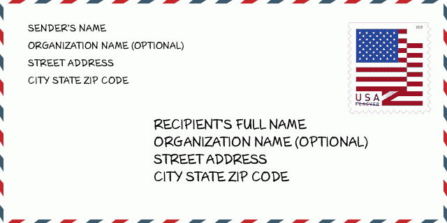
66002-7221 ตัวอย่างซองจดหมาย

-
นี่คือตัวอย่างซองจดหมายของสหรัฐฯ กรอกข้อมูลผู้ส่งที่ด้านบนซ้ายและข้อมูลผู้รับที่ด้านล่างขวา ข้อมูลที่จำเป็นคือชื่อเต็มของผู้ส่ง/ผู้รับ ที่อยู่ เมือง รัฐ และรหัสไปรษณีย์ ข้อมูลที่อยู่ผู้รับได้รับสำหรับการอ้างอิงของคุณ โดยทั่วไป หากคุณไม่แน่ใจเกี่ยวกับรหัสไปรษณีย์ 9 หลักแบบเต็ม คุณสามารถกรอกรหัสไปรษณีย์ 5 หลักเท่านั้นเพื่อหลีกเลี่ยงการสูญหายของพัสดุ
66002-7221 ความหมายพื้นฐาน
-
รหัสไปรษณีย์ 66002-7221 แต่ละหลักย่อมาจากอะไร ? รหัสไปรษณีย์ประกอบด้วยสองส่วน โดยสามารถระบุหมายเลขห้าหลักแรกไปยังที่ทำการไปรษณีย์ได้ และตัวเลขสี่หลักสุดท้ายสามารถระบุส่วนทางภูมิศาสตร์ภายในพื้นที่จัดส่งห้าหลักได้ ตัวเลข 6-7 หลักกำหนดส่วนหรือหลายช่วงตึก และตัวเลข 8-9 หลักกำหนดส่วนหรือด้านใดด้านหนึ่งของถนน
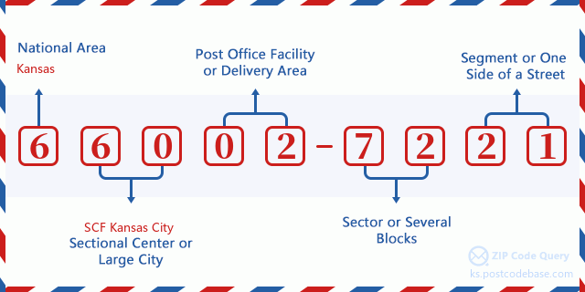

- · Idเส้นทางการขนส่ง?
A 4-digit code assigned to a mail delivery or collection route within a 5-digit ZIP Code. The first character of this identification is alphabetical, and the last three are numeric: Bnnn = PO box Hnnn = Highway contract Rnnn = Rural route Cnnn = City delivery Gnnn = General delivery: R002 (สายชนบท)
- ·ภาคต่ำเพิ่มเติมทางไปรษณีย์?
The ZIP Add-On Low Sector and the ZIP Add-On Low Segment together form the ZIP Add-On Low Number. The ZIP Add-On Low Number is the last four positions of a ZIP+4 code; the low-end ZIP add-on in a range of codes; the add-on of the first ZIP+4 code in a consecutive series of ZIP+4 codes assigned to the delivery address. For example, most delivery addresses are assigned a single ZIP+4 code. However, large companies may be given a range of ZIP+4 codes that can be used to route mail to specific departments. A range of ZIP+4 codes can also be assigned to a corresponding range of post office boxes, and each box is mapped, one-to-one, with a ZIP+4 code in the range. A single post office box can also be assigned a range of ZIP+4 codes.: 72
- ·ส่วนต่ำเพิ่มเติมทางไปรษณีย์?
The ZIP Add-On Low Sector and the ZIP Add-On Low Segment together form the ZIP Add-On Low Number. The ZIP Add-On Low Number is the last four positions of a ZIP+4 code; the low-end ZIP add-on in a range of codes; the add-on of the first ZIP+4 code in a consecutive series of ZIP+4 codes assigned to the delivery address. For example, most delivery addresses are assigned a single ZIP+4 code. However, large companies may be given a range of ZIP+4 codes that can be used to route mail to specific departments. A range of ZIP+4 codes can also be assigned to a corresponding range of post office boxes, and each box is mapped, one-to-one, with a ZIP+4 code in the range. A single post office box can also be assigned a range of ZIP+4 codes.: 21
- ·ภาคสูงเพิ่มเติมทางไปรษณีย์?
The ZIP Add-On High Sector and the ZIP Add-On High Segment together form the ZIP Add-On High Number, which is the high-end ZIP add-on in a range of codes; the add-on of the last ZIP+4 code in a consecutive series of ZIP+4 codes assigned to the delivery address. Most delivery addresses are assigned a single ZIP+4 code; however, large companies may be given a range of ZIP+4 codes that can be used to route mail to specific departments. A range of ZIP+4 codes can also be assigned to a corresponding range of post office boxes, and each box is mapped, one-to-one, with a ZIP+4 code in the range. A single post office box can also be assigned a range of ZIP+4 codes. (See also ZIP Add-On Code.): 72
- ·ส่วนสูงเพิ่มเติมทางไปรษณีย์?
The ZIP Add-On High Sector and the ZIP Add-On High Segment together form the ZIP Add-On High Number, which is the high-end ZIP add-on in a range of codes; the add-on of the last ZIP+4 code in a consecutive series of ZIP+4 codes assigned to the delivery address. Most delivery addresses are assigned a single ZIP+4 code; however, large companies may be given a range of ZIP+4 codes that can be used to route mail to specific departments. A range of ZIP+4 codes can also be assigned to a corresponding range of post office boxes, and each box is mapped, one-to-one, with a ZIP+4 code in the range. A single post office box can also be assigned a range of ZIP+4 codes. (See also ZIP Add-On Code.): 21
- ·รหัสไปรษณีย์ เพิ่มเติม: 7221
- ·เทือกเขา?
The range of +4 codes. Summing the +4 Code and the +4 Range will give you the high end of the range of +4 Codes that pertain to this ZIP Code.: 0
- ·รหัสแทนขั้นพื้นฐาน?
Code that specifies whether a record is a base (preferred) or alternate record. Base records (represented as "B") can represent a range of addresses or an individual address, such as a firm record, while alternate records (represented as "A") are individual delivery points. Government deliveries will only be listed on alternate records with the appropriate government building indicator (federal, state, or city) set.: พื้นฐาน
- ·ตัวเลขทางการเงิน?
A code assigned to Postal Service facilities (primarily post offices) to collect cost and statistical data and compile revenue and expense data. The state number comprises the first two positions of the finance number.: 190517
- ·ตัวเลขแขวงรัฐสภา?
A standard value identifying a geographic area within the United States served by a member of the US House of Representatives or Senate. If Army/Air Force (APO) or fleet post office (FPO), this column will be blank. If there is only one member of Congress within a state, the code will be "AL" (at large).: 02
- ·รหัสรัฐเมืองบรรทัดสุดท้าย?
An index to the City State file that provides the preferred last-line name for this address range.: W20074
แผนที่ออนไลน์

นี่คือแผนที่อิเล็กทรอนิกส์ออนไลน์ที่ที่อยู่ 1400 95TH RD, ATCHISONจับคู่นั้น คุณสามารถจะใช้ปุ่มบนแผนที่เพื่อเลื่อนและซูม ข้อมูลแผนที่นี้ เฉพาะสำหรับการอ้างอิงเท่านั้น
ที่อยู่: 1400 (From 1400 To 1499) 95TH RD, ATCHISON, KS 66002-7221, USA
ความเห็น


แสดงความเห็น