주소: 20200 (From 20200 To 20299) THOMAS RD, ATCHISON, KS 66002-5007, USA
66002-5007은 무엇입니까? 66002-5007 20200 (From 20200 To 20299) THOMAS RD, ATCHISON, KS, USA 의 5플러스 4 우편번호입니다. 다음은 세부정보입니다.
66002-5007 기본 정보

-
우편 번호 5 플러스 4:
66002-5007 -
우편 번호 5:
66002 -
플러스 4?50074-digits that are used to identify a geographic segment within the 5-digit delivery area, such as a city block or a group of apartments or an individual high-volume receiver of mail, or any other unit that could use an extra identifier to aid in efficient mail sorting and delivery. This code is the low end of the range of +4 Codes that pertain to this ZIP Code. ZIP+4 Codes associated with nondelivery areas are composed of valid ZIP sector numbers and "ND" for the ZIP segment number, for example 12345-12ND. Non-deliverable areas are areas to which the USPS does not deliver mail, such as vacant lots and land that borders railroad tracks. Mailers should not match an address identified as a nondelivery area. If you absolutely must have numeric characters in the Plus4Code column, you may treat "ND" values as "00" (zero zero).:
-
나라:
U.S. - 미국 -
주:
KS - 캔자스 -
군:
CountyFIPS: 20087 - Jefferson County -
도시:
ATCHISON -
거리?THOMAS RDThe official name of a street as assigned by a local governing authority. The Street Name column contains only the street name and does not include directionals (EAST, WEST, etc.) or suffixes (ST, DR, BLVD, etc.). This element may also contain literals, such as PO BOX, GENERAL DELIVERY, USS, PSC, or UNIT. Numeric street names that have numeric components that are four characters (or less) in length at are justified such that the low-order digit of the number is positioned in the fourth position of the street name column. This shift is made so that the numeric street names appear in numeric sequence.:
-
거리 접미사?RD (도로)The street suffix: For Example: ST = Street RD = Road DR = Drive LN = Lane:
-
기록 유형?S: 거리An alphabetic value that identifies the type of data in the record. Record type codes include the following: G = General delivery H = Highrise F = Firm S = Street P = PO box R = Rural route/highway contract:
주소

- 주요 주소 낮은 수치?
A house, rural route, highway contract box, or post office box number; the numeric or alphanumeric component of an address preceding the street name; the low-end address in a range of addresses. Often referred to as house number.: 20200
- 주요 주소 높은 수치?
A house, rural route, contract box, or Post Office box number. The numeric or alphanumeric component of an address preceding the street name. The high-end address in a range of addresses. Often referred to as house number.: 20299
- 주요 주소 홀수/짝수 코드?
Code that identifies the side or sides of a street for which a given address range is applicable. For street, highrise, firm and multi-carrier records, B = Both sides of a street, E = Even side of a street (even-numbered addresses in the range); O = Odd side of a street (odd-numbered addresses in the range). For general delivery, post office box, and rural route/highway contract records, this code will always be "B" (both).: Both of Odd and Even
- 일 순위 범위: 20200, 20201, 20202, 20203, 20204, 20205, 20206, 20207, 20208, 20209, 20210, 20211, 20212, 20213, 20214, 20215, 20216, 20217, 20218, 20219, 20220, 20221, 20222, 20223, 20224, 20225, 20226, 20227, 20228, 20229, 20230, 20231, 20232, 20233, 20234, 20235, 20236, 20237, 20238, 20239, 20240, 20241, 20242, 20243, 20244, 20245, 20246, 20247, 20248, 20249, 20250, 20251, 20252, 20253, 20254, 20255, 20256, 20257, 20258, 20259, 20260, 20261, 20262, 20263, 20264, 20265, 20266, 20267, 20268, 20269, 20270, 20271, 20272, 20273, 20274, 20275, 20276, 20277, 20278, 20279, 20280, 20281, 20282, 20283, 20284, 20285, 20286, 20287, 20288, 20289, 20290, 20291, 20292, 20293, 20294, 20295, 20296, 20297, 20298, 20299.
전체 목록을 보려면 "더 많은 주소 예시"을 클릭하십시오.
20200 THOMAS RD, ATCHISON, KS 66002-5007
20201 THOMAS RD, ATCHISON, KS 66002-5007
20202 THOMAS RD, ATCHISON, KS 66002-5007
20203 THOMAS RD, ATCHISON, KS 66002-5007
20204 THOMAS RD, ATCHISON, KS 66002-5007
20205 THOMAS RD, ATCHISON, KS 66002-5007
20206 THOMAS RD, ATCHISON, KS 66002-5007
20207 THOMAS RD, ATCHISON, KS 66002-5007
20208 THOMAS RD, ATCHISON, KS 66002-5007
20209 THOMAS RD, ATCHISON, KS 66002-5007
20210 THOMAS RD, ATCHISON, KS 66002-5007
20211 THOMAS RD, ATCHISON, KS 66002-5007
20212 THOMAS RD, ATCHISON, KS 66002-5007
20213 THOMAS RD, ATCHISON, KS 66002-5007
20214 THOMAS RD, ATCHISON, KS 66002-5007
20215 THOMAS RD, ATCHISON, KS 66002-5007
20216 THOMAS RD, ATCHISON, KS 66002-5007
20217 THOMAS RD, ATCHISON, KS 66002-5007
20218 THOMAS RD, ATCHISON, KS 66002-5007
20219 THOMAS RD, ATCHISON, KS 66002-5007
20220 THOMAS RD, ATCHISON, KS 66002-5007
20221 THOMAS RD, ATCHISON, KS 66002-5007
20222 THOMAS RD, ATCHISON, KS 66002-5007
20223 THOMAS RD, ATCHISON, KS 66002-5007
20224 THOMAS RD, ATCHISON, KS 66002-5007
20225 THOMAS RD, ATCHISON, KS 66002-5007
20226 THOMAS RD, ATCHISON, KS 66002-5007
20227 THOMAS RD, ATCHISON, KS 66002-5007
20228 THOMAS RD, ATCHISON, KS 66002-5007
20229 THOMAS RD, ATCHISON, KS 66002-5007
20230 THOMAS RD, ATCHISON, KS 66002-5007
20231 THOMAS RD, ATCHISON, KS 66002-5007
20232 THOMAS RD, ATCHISON, KS 66002-5007
20233 THOMAS RD, ATCHISON, KS 66002-5007
20234 THOMAS RD, ATCHISON, KS 66002-5007
20235 THOMAS RD, ATCHISON, KS 66002-5007
20236 THOMAS RD, ATCHISON, KS 66002-5007
20237 THOMAS RD, ATCHISON, KS 66002-5007
20238 THOMAS RD, ATCHISON, KS 66002-5007
20239 THOMAS RD, ATCHISON, KS 66002-5007
20240 THOMAS RD, ATCHISON, KS 66002-5007
20241 THOMAS RD, ATCHISON, KS 66002-5007
20242 THOMAS RD, ATCHISON, KS 66002-5007
20243 THOMAS RD, ATCHISON, KS 66002-5007
20244 THOMAS RD, ATCHISON, KS 66002-5007
20245 THOMAS RD, ATCHISON, KS 66002-5007
20246 THOMAS RD, ATCHISON, KS 66002-5007
20247 THOMAS RD, ATCHISON, KS 66002-5007
20248 THOMAS RD, ATCHISON, KS 66002-5007
20249 THOMAS RD, ATCHISON, KS 66002-5007
20250 THOMAS RD, ATCHISON, KS 66002-5007
20251 THOMAS RD, ATCHISON, KS 66002-5007
20252 THOMAS RD, ATCHISON, KS 66002-5007
20253 THOMAS RD, ATCHISON, KS 66002-5007
20254 THOMAS RD, ATCHISON, KS 66002-5007
20255 THOMAS RD, ATCHISON, KS 66002-5007
20256 THOMAS RD, ATCHISON, KS 66002-5007
20257 THOMAS RD, ATCHISON, KS 66002-5007
20258 THOMAS RD, ATCHISON, KS 66002-5007
20259 THOMAS RD, ATCHISON, KS 66002-5007
20260 THOMAS RD, ATCHISON, KS 66002-5007
20261 THOMAS RD, ATCHISON, KS 66002-5007
20262 THOMAS RD, ATCHISON, KS 66002-5007
20263 THOMAS RD, ATCHISON, KS 66002-5007
20264 THOMAS RD, ATCHISON, KS 66002-5007
20265 THOMAS RD, ATCHISON, KS 66002-5007
20266 THOMAS RD, ATCHISON, KS 66002-5007
20267 THOMAS RD, ATCHISON, KS 66002-5007
20268 THOMAS RD, ATCHISON, KS 66002-5007
20269 THOMAS RD, ATCHISON, KS 66002-5007
20270 THOMAS RD, ATCHISON, KS 66002-5007
20271 THOMAS RD, ATCHISON, KS 66002-5007
20272 THOMAS RD, ATCHISON, KS 66002-5007
20273 THOMAS RD, ATCHISON, KS 66002-5007
20274 THOMAS RD, ATCHISON, KS 66002-5007
20275 THOMAS RD, ATCHISON, KS 66002-5007
20276 THOMAS RD, ATCHISON, KS 66002-5007
20277 THOMAS RD, ATCHISON, KS 66002-5007
20278 THOMAS RD, ATCHISON, KS 66002-5007
20279 THOMAS RD, ATCHISON, KS 66002-5007
20280 THOMAS RD, ATCHISON, KS 66002-5007
20281 THOMAS RD, ATCHISON, KS 66002-5007
20282 THOMAS RD, ATCHISON, KS 66002-5007
20283 THOMAS RD, ATCHISON, KS 66002-5007
20284 THOMAS RD, ATCHISON, KS 66002-5007
20285 THOMAS RD, ATCHISON, KS 66002-5007
20286 THOMAS RD, ATCHISON, KS 66002-5007
20287 THOMAS RD, ATCHISON, KS 66002-5007
20288 THOMAS RD, ATCHISON, KS 66002-5007
20289 THOMAS RD, ATCHISON, KS 66002-5007
20290 THOMAS RD, ATCHISON, KS 66002-5007
20291 THOMAS RD, ATCHISON, KS 66002-5007
20292 THOMAS RD, ATCHISON, KS 66002-5007
20293 THOMAS RD, ATCHISON, KS 66002-5007
20294 THOMAS RD, ATCHISON, KS 66002-5007
20295 THOMAS RD, ATCHISON, KS 66002-5007
20296 THOMAS RD, ATCHISON, KS 66002-5007
20297 THOMAS RD, ATCHISON, KS 66002-5007
20298 THOMAS RD, ATCHISON, KS 66002-5007
20299 THOMAS RD, ATCHISON, KS 66002-5007
주소 예제
ATCHISON KS 66002-5007
UNITED STATES OF AMERICA
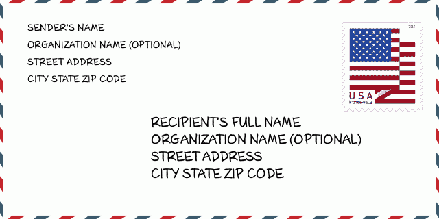
66002-5007 봉투 예제

-
이것은 미국 봉투의 예입니다. 왼쪽 상단에 보낸 사람 정보를 입력하고 오른쪽 하단에 받는 사람 정보를 입력합니다. 필요한 정보는 보낸 사람/받는 사람의 전체 이름, 주소, 도시, 주 및 우편 번호입니다. 수신자 주소 정보는 참조용으로 제공되었습니다. 일반적으로 전체 9자리 우편번호가 확실하지 않은 경우 패키지 분실을 방지하기 위해 5자리 우편번호만 입력할 수 있습니다.
66002-5007 기본 의미
-
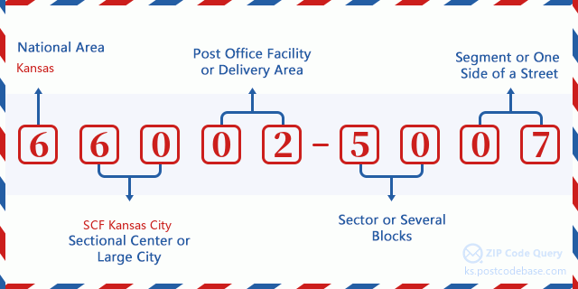
우편번호 66002-5007의 각 숫자는 무엇을 의미합니까? ZIP+4 코드는 두 부분으로 구성되며 처음 5자리는 우체국에 위치할 수 있고 마지막 4자리는 5자리 배달 지역 내 지리적 세그먼트를 식별할 수 있습니다. 6-7자리는 섹터 또는 여러 블록을 지정하고 8-9자리는 도로의 세그먼트 또는 한 면을 지정합니다.

- ·교통 노선 ID?
A 4-digit code assigned to a mail delivery or collection route within a 5-digit ZIP Code. The first character of this identification is alphabetical, and the last three are numeric: Bnnn = PO box Hnnn = Highway contract Rnnn = Rural route Cnnn = City delivery Gnnn = General delivery: R003 (농촌 루트)
- ·우편 추가 하부?
The ZIP Add-On Low Sector and the ZIP Add-On Low Segment together form the ZIP Add-On Low Number. The ZIP Add-On Low Number is the last four positions of a ZIP+4 code; the low-end ZIP add-on in a range of codes; the add-on of the first ZIP+4 code in a consecutive series of ZIP+4 codes assigned to the delivery address. For example, most delivery addresses are assigned a single ZIP+4 code. However, large companies may be given a range of ZIP+4 codes that can be used to route mail to specific departments. A range of ZIP+4 codes can also be assigned to a corresponding range of post office boxes, and each box is mapped, one-to-one, with a ZIP+4 code in the range. A single post office box can also be assigned a range of ZIP+4 codes.: 50
- ·우편 추가 낮은 섹션?
The ZIP Add-On Low Sector and the ZIP Add-On Low Segment together form the ZIP Add-On Low Number. The ZIP Add-On Low Number is the last four positions of a ZIP+4 code; the low-end ZIP add-on in a range of codes; the add-on of the first ZIP+4 code in a consecutive series of ZIP+4 codes assigned to the delivery address. For example, most delivery addresses are assigned a single ZIP+4 code. However, large companies may be given a range of ZIP+4 codes that can be used to route mail to specific departments. A range of ZIP+4 codes can also be assigned to a corresponding range of post office boxes, and each box is mapped, one-to-one, with a ZIP+4 code in the range. A single post office box can also be assigned a range of ZIP+4 codes.: 07
- ·우편 추가 높은 섹션?
The ZIP Add-On High Sector and the ZIP Add-On High Segment together form the ZIP Add-On High Number, which is the high-end ZIP add-on in a range of codes; the add-on of the last ZIP+4 code in a consecutive series of ZIP+4 codes assigned to the delivery address. Most delivery addresses are assigned a single ZIP+4 code; however, large companies may be given a range of ZIP+4 codes that can be used to route mail to specific departments. A range of ZIP+4 codes can also be assigned to a corresponding range of post office boxes, and each box is mapped, one-to-one, with a ZIP+4 code in the range. A single post office box can also be assigned a range of ZIP+4 codes. (See also ZIP Add-On Code.): 50
- ·우편 추가 높은 세그먼트?
The ZIP Add-On High Sector and the ZIP Add-On High Segment together form the ZIP Add-On High Number, which is the high-end ZIP add-on in a range of codes; the add-on of the last ZIP+4 code in a consecutive series of ZIP+4 codes assigned to the delivery address. Most delivery addresses are assigned a single ZIP+4 code; however, large companies may be given a range of ZIP+4 codes that can be used to route mail to specific departments. A range of ZIP+4 codes can also be assigned to a corresponding range of post office boxes, and each box is mapped, one-to-one, with a ZIP+4 code in the range. A single post office box can also be assigned a range of ZIP+4 codes. (See also ZIP Add-On Code.): 07
- ·우편 번호 추가: 5007
- ·범위?
The range of +4 codes. Summing the +4 Code and the +4 Range will give you the high end of the range of +4 Codes that pertain to this ZIP Code.: 0
- ·기본 대체 코드?
Code that specifies whether a record is a base (preferred) or alternate record. Base records (represented as "B") can represent a range of addresses or an individual address, such as a firm record, while alternate records (represented as "A") are individual delivery points. Government deliveries will only be listed on alternate records with the appropriate government building indicator (federal, state, or city) set.: 기본
- ·재무 수치?
A code assigned to Postal Service facilities (primarily post offices) to collect cost and statistical data and compile revenue and expense data. The state number comprises the first two positions of the finance number.: 190517
- ·국회 지역 숫자?
A standard value identifying a geographic area within the United States served by a member of the US House of Representatives or Senate. If Army/Air Force (APO) or fleet post office (FPO), this column will be blank. If there is only one member of Congress within a state, the code will be "AL" (at large).: 02
- ·마지막 줄 도시 주 코드?
An index to the City State file that provides the preferred last-line name for this address range.: W20074
온라인 지도

주소입니다 20200 THOMAS RD, ATCHISON 상응한 온라인 전자지도입니다. 이동 및 줌 버튼을 사용할 수 있습니다. 지도 정보는 참고용입니다.
주소: 20200 (From 20200 To 20299) THOMAS RD, ATCHISON, KS 66002-5007, USA
댓글


댓글 달기