نشانی: 1000 (From 1000 To 1099) ROAD 27, ROLLA, KS 67954-5518, USA
؟67954-5518 چیست 67954-5518 یک کد فشرده 5 به همراه 4 عدد از 1000 (From 1000 To 1099) ROAD 27, ROLLA, KS, USA است. اطلاعات بیشتر در زیر آمده است.
67954-5518 اطلاعات اولیه

-
کد پستی 5 به علاوه 4:
67954-5518 -
کد پستی 5:
67954 -
به علاوه 4?55184-digits that are used to identify a geographic segment within the 5-digit delivery area, such as a city block or a group of apartments or an individual high-volume receiver of mail, or any other unit that could use an extra identifier to aid in efficient mail sorting and delivery. This code is the low end of the range of +4 Codes that pertain to this ZIP Code. ZIP+4 Codes associated with nondelivery areas are composed of valid ZIP sector numbers and "ND" for the ZIP segment number, for example 12345-12ND. Non-deliverable areas are areas to which the USPS does not deliver mail, such as vacant lots and land that borders railroad tracks. Mailers should not match an address identified as a nondelivery area. If you absolutely must have numeric characters in the Plus4Code column, you may treat "ND" values as "00" (zero zero).:
-
کشور:
U.S. - ایالات متحده -
دولت:
KS - کانزاس -
شهرستان:
CountyFIPS: 20189 - Stevens County -
شهر:
ROLLA -
خیابان?ROAD 27The official name of a street as assigned by a local governing authority. The Street Name column contains only the street name and does not include directionals (EAST, WEST, etc.) or suffixes (ST, DR, BLVD, etc.). This element may also contain literals, such as PO BOX, GENERAL DELIVERY, USS, PSC, or UNIT. Numeric street names that have numeric components that are four characters (or less) in length at are justified such that the low-order digit of the number is positioned in the fourth position of the street name column. This shift is made so that the numeric street names appear in numeric sequence.:
-
نوع ثبت?S: خیابانAn alphabetic value that identifies the type of data in the record. Record type codes include the following: G = General delivery H = Highrise F = Firm S = Street P = PO box R = Rural route/highway contract:
نشانی

- شماره پایین آدرس اولیه?
A house, rural route, highway contract box, or post office box number; the numeric or alphanumeric component of an address preceding the street name; the low-end address in a range of addresses. Often referred to as house number.: 1000
- شماره بالا آدرس اولیه?
A house, rural route, contract box, or Post Office box number. The numeric or alphanumeric component of an address preceding the street name. The high-end address in a range of addresses. Often referred to as house number.: 1099
- کد فرد/ زوج آدرس اولیه?
Code that identifies the side or sides of a street for which a given address range is applicable. For street, highrise, firm and multi-carrier records, B = Both sides of a street, E = Even side of a street (even-numbered addresses in the range); O = Odd side of a street (odd-numbered addresses in the range). For general delivery, post office box, and rural route/highway contract records, this code will always be "B" (both).: Both of Odd and Even
- اولیه محدوده: 1000, 1001, 1002, 1003, 1004, 1005, 1006, 1007, 1008, 1009, 1010, 1011, 1012, 1013, 1014, 1015, 1016, 1017, 1018, 1019, 1020, 1021, 1022, 1023, 1024, 1025, 1026, 1027, 1028, 1029, 1030, 1031, 1032, 1033, 1034, 1035, 1036, 1037, 1038, 1039, 1040, 1041, 1042, 1043, 1044, 1045, 1046, 1047, 1048, 1049, 1050, 1051, 1052, 1053, 1054, 1055, 1056, 1057, 1058, 1059, 1060, 1061, 1062, 1063, 1064, 1065, 1066, 1067, 1068, 1069, 1070, 1071, 1072, 1073, 1074, 1075, 1076, 1077, 1078, 1079, 1080, 1081, 1082, 1083, 1084, 1085, 1086, 1087, 1088, 1089, 1090, 1091, 1092, 1093, 1094, 1095, 1096, 1097, 1098, 1099.
لطفاً برای مشاهده کل لیست ، بر روی "نمونه های آدرس بیشتر" کلیک کنید.
1000 ROAD 27, ROLLA, KS 67954-5518
1001 ROAD 27, ROLLA, KS 67954-5518
1002 ROAD 27, ROLLA, KS 67954-5518
1003 ROAD 27, ROLLA, KS 67954-5518
1004 ROAD 27, ROLLA, KS 67954-5518
1005 ROAD 27, ROLLA, KS 67954-5518
1006 ROAD 27, ROLLA, KS 67954-5518
1007 ROAD 27, ROLLA, KS 67954-5518
1008 ROAD 27, ROLLA, KS 67954-5518
1009 ROAD 27, ROLLA, KS 67954-5518
1010 ROAD 27, ROLLA, KS 67954-5518
1011 ROAD 27, ROLLA, KS 67954-5518
1012 ROAD 27, ROLLA, KS 67954-5518
1013 ROAD 27, ROLLA, KS 67954-5518
1014 ROAD 27, ROLLA, KS 67954-5518
1015 ROAD 27, ROLLA, KS 67954-5518
1016 ROAD 27, ROLLA, KS 67954-5518
1017 ROAD 27, ROLLA, KS 67954-5518
1018 ROAD 27, ROLLA, KS 67954-5518
1019 ROAD 27, ROLLA, KS 67954-5518
1020 ROAD 27, ROLLA, KS 67954-5518
1021 ROAD 27, ROLLA, KS 67954-5518
1022 ROAD 27, ROLLA, KS 67954-5518
1023 ROAD 27, ROLLA, KS 67954-5518
1024 ROAD 27, ROLLA, KS 67954-5518
1025 ROAD 27, ROLLA, KS 67954-5518
1026 ROAD 27, ROLLA, KS 67954-5518
1027 ROAD 27, ROLLA, KS 67954-5518
1028 ROAD 27, ROLLA, KS 67954-5518
1029 ROAD 27, ROLLA, KS 67954-5518
1030 ROAD 27, ROLLA, KS 67954-5518
1031 ROAD 27, ROLLA, KS 67954-5518
1032 ROAD 27, ROLLA, KS 67954-5518
1033 ROAD 27, ROLLA, KS 67954-5518
1034 ROAD 27, ROLLA, KS 67954-5518
1035 ROAD 27, ROLLA, KS 67954-5518
1036 ROAD 27, ROLLA, KS 67954-5518
1037 ROAD 27, ROLLA, KS 67954-5518
1038 ROAD 27, ROLLA, KS 67954-5518
1039 ROAD 27, ROLLA, KS 67954-5518
1040 ROAD 27, ROLLA, KS 67954-5518
1041 ROAD 27, ROLLA, KS 67954-5518
1042 ROAD 27, ROLLA, KS 67954-5518
1043 ROAD 27, ROLLA, KS 67954-5518
1044 ROAD 27, ROLLA, KS 67954-5518
1045 ROAD 27, ROLLA, KS 67954-5518
1046 ROAD 27, ROLLA, KS 67954-5518
1047 ROAD 27, ROLLA, KS 67954-5518
1048 ROAD 27, ROLLA, KS 67954-5518
1049 ROAD 27, ROLLA, KS 67954-5518
1050 ROAD 27, ROLLA, KS 67954-5518
1051 ROAD 27, ROLLA, KS 67954-5518
1052 ROAD 27, ROLLA, KS 67954-5518
1053 ROAD 27, ROLLA, KS 67954-5518
1054 ROAD 27, ROLLA, KS 67954-5518
1055 ROAD 27, ROLLA, KS 67954-5518
1056 ROAD 27, ROLLA, KS 67954-5518
1057 ROAD 27, ROLLA, KS 67954-5518
1058 ROAD 27, ROLLA, KS 67954-5518
1059 ROAD 27, ROLLA, KS 67954-5518
1060 ROAD 27, ROLLA, KS 67954-5518
1061 ROAD 27, ROLLA, KS 67954-5518
1062 ROAD 27, ROLLA, KS 67954-5518
1063 ROAD 27, ROLLA, KS 67954-5518
1064 ROAD 27, ROLLA, KS 67954-5518
1065 ROAD 27, ROLLA, KS 67954-5518
1066 ROAD 27, ROLLA, KS 67954-5518
1067 ROAD 27, ROLLA, KS 67954-5518
1068 ROAD 27, ROLLA, KS 67954-5518
1069 ROAD 27, ROLLA, KS 67954-5518
1070 ROAD 27, ROLLA, KS 67954-5518
1071 ROAD 27, ROLLA, KS 67954-5518
1072 ROAD 27, ROLLA, KS 67954-5518
1073 ROAD 27, ROLLA, KS 67954-5518
1074 ROAD 27, ROLLA, KS 67954-5518
1075 ROAD 27, ROLLA, KS 67954-5518
1076 ROAD 27, ROLLA, KS 67954-5518
1077 ROAD 27, ROLLA, KS 67954-5518
1078 ROAD 27, ROLLA, KS 67954-5518
1079 ROAD 27, ROLLA, KS 67954-5518
1080 ROAD 27, ROLLA, KS 67954-5518
1081 ROAD 27, ROLLA, KS 67954-5518
1082 ROAD 27, ROLLA, KS 67954-5518
1083 ROAD 27, ROLLA, KS 67954-5518
1084 ROAD 27, ROLLA, KS 67954-5518
1085 ROAD 27, ROLLA, KS 67954-5518
1086 ROAD 27, ROLLA, KS 67954-5518
1087 ROAD 27, ROLLA, KS 67954-5518
1088 ROAD 27, ROLLA, KS 67954-5518
1089 ROAD 27, ROLLA, KS 67954-5518
1090 ROAD 27, ROLLA, KS 67954-5518
1091 ROAD 27, ROLLA, KS 67954-5518
1092 ROAD 27, ROLLA, KS 67954-5518
1093 ROAD 27, ROLLA, KS 67954-5518
1094 ROAD 27, ROLLA, KS 67954-5518
1095 ROAD 27, ROLLA, KS 67954-5518
1096 ROAD 27, ROLLA, KS 67954-5518
1097 ROAD 27, ROLLA, KS 67954-5518
1098 ROAD 27, ROLLA, KS 67954-5518
1099 ROAD 27, ROLLA, KS 67954-5518
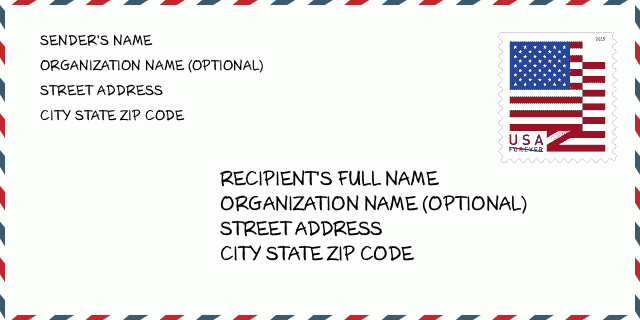
نشانی مثال
ROLLA KS 67954-5518
UNITED STATES OF AMERICA
67954-5518 نمونه پاکت

-
این نمونه ای از پاکت نامه ایالات متحده است. اطلاعات فرستنده را در بالا سمت چپ و اطلاعات گیرنده را در پایین سمت راست وارد کنید. اطلاعات لازم نام کامل فرستنده/گیرنده ، آدرس خیابان ، شهر ، ایالت و کد پستی است. اطلاعات آدرس گیرنده برای مرجع شما داده شده است. به طور کلی ، اگر از کد پستی کامل 9 رقمی مطمئن نیستید ، فقط می توانید کد پستی 5 رقمی را پر کنید تا از دست دادن بسته جلوگیری شود.
67954-5518 معنای اساسی
-
هر رقم کد پستی 67954-5518 مخفف چیست؟ کد ZIP+4 از دو بخش تشکیل شده است، پنج رقم اول را می توان در اداره پست قرار داد، و چهار رقم آخر می تواند یک بخش جغرافیایی را در منطقه تحویل پنج رقمی مشخص کند. 6-7 رقم بخش یا چند بلوک را مشخص می کند و رقم 8-9 نشان دهنده بخش یا یک طرف خیابان است.
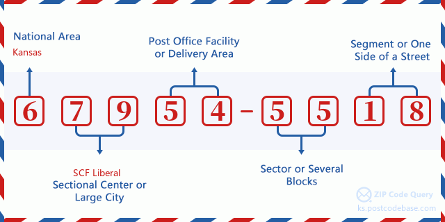

- ·شناسایی مسیر حامل?
A 4-digit code assigned to a mail delivery or collection route within a 5-digit ZIP Code. The first character of this identification is alphabetical, and the last three are numeric: Bnnn = PO box Hnnn = Highway contract Rnnn = Rural route Cnnn = City delivery Gnnn = General delivery: H002 (قرارداد بزرگراه)
- ·بخش پایین افزونه فشرده?
The ZIP Add-On Low Sector and the ZIP Add-On Low Segment together form the ZIP Add-On Low Number. The ZIP Add-On Low Number is the last four positions of a ZIP+4 code; the low-end ZIP add-on in a range of codes; the add-on of the first ZIP+4 code in a consecutive series of ZIP+4 codes assigned to the delivery address. For example, most delivery addresses are assigned a single ZIP+4 code. However, large companies may be given a range of ZIP+4 codes that can be used to route mail to specific departments. A range of ZIP+4 codes can also be assigned to a corresponding range of post office boxes, and each box is mapped, one-to-one, with a ZIP+4 code in the range. A single post office box can also be assigned a range of ZIP+4 codes.: 55
- ·بخش پایین افزونه فشرده?
The ZIP Add-On Low Sector and the ZIP Add-On Low Segment together form the ZIP Add-On Low Number. The ZIP Add-On Low Number is the last four positions of a ZIP+4 code; the low-end ZIP add-on in a range of codes; the add-on of the first ZIP+4 code in a consecutive series of ZIP+4 codes assigned to the delivery address. For example, most delivery addresses are assigned a single ZIP+4 code. However, large companies may be given a range of ZIP+4 codes that can be used to route mail to specific departments. A range of ZIP+4 codes can also be assigned to a corresponding range of post office boxes, and each box is mapped, one-to-one, with a ZIP+4 code in the range. A single post office box can also be assigned a range of ZIP+4 codes.: 18
- ·بخش بالا افزونه فشرده?
The ZIP Add-On High Sector and the ZIP Add-On High Segment together form the ZIP Add-On High Number, which is the high-end ZIP add-on in a range of codes; the add-on of the last ZIP+4 code in a consecutive series of ZIP+4 codes assigned to the delivery address. Most delivery addresses are assigned a single ZIP+4 code; however, large companies may be given a range of ZIP+4 codes that can be used to route mail to specific departments. A range of ZIP+4 codes can also be assigned to a corresponding range of post office boxes, and each box is mapped, one-to-one, with a ZIP+4 code in the range. A single post office box can also be assigned a range of ZIP+4 codes. (See also ZIP Add-On Code.): 55
- ·بخش بالا افزونه فشرده?
The ZIP Add-On High Sector and the ZIP Add-On High Segment together form the ZIP Add-On High Number, which is the high-end ZIP add-on in a range of codes; the add-on of the last ZIP+4 code in a consecutive series of ZIP+4 codes assigned to the delivery address. Most delivery addresses are assigned a single ZIP+4 code; however, large companies may be given a range of ZIP+4 codes that can be used to route mail to specific departments. A range of ZIP+4 codes can also be assigned to a corresponding range of post office boxes, and each box is mapped, one-to-one, with a ZIP+4 code in the range. A single post office box can also be assigned a range of ZIP+4 codes. (See also ZIP Add-On Code.): 18
- ·کد پستی افزونه: 5518
- ·محدوده?
The range of +4 codes. Summing the +4 Code and the +4 Range will give you the high end of the range of +4 Codes that pertain to this ZIP Code.: 0
- ·کد متناوب پایه?
Code that specifies whether a record is a base (preferred) or alternate record. Base records (represented as "B") can represent a range of addresses or an individual address, such as a firm record, while alternate records (represented as "A") are individual delivery points. Government deliveries will only be listed on alternate records with the appropriate government building indicator (federal, state, or city) set.: پایه
- ·شماره مالی?
A code assigned to Postal Service facilities (primarily post offices) to collect cost and statistical data and compile revenue and expense data. The state number comprises the first two positions of the finance number.: 197843
- ·شماره ناحیه کنگره?
A standard value identifying a geographic area within the United States served by a member of the US House of Representatives or Senate. If Army/Air Force (APO) or fleet post office (FPO), this column will be blank. If there is only one member of Congress within a state, the code will be "AL" (at large).: 01
- ·کلید دولتی خط نهایی ترجیحی?
An index to the City State file that provides the preferred last-line name for this address range.: W21307
نقشه آنلاین

این نقشه آنلاین آدرس 1000 ROAD 27 ROLLA است. برای حرکت و زوم میتوانید از دکمه استفاده کنید. اطلاعات نقشه تنها برای مرجع است.
نشانی: 1000 (From 1000 To 1099) ROAD 27, ROLLA, KS 67954-5518, USA
دیدگاه


افزودن دیدگاه جدید