نشانی: 1900 (From 1900 To 1999) COUNTY RD 1077, BLUE MOUND, KS 66010-9403, USA
؟66010-9403 چیست 66010-9403 یک کد فشرده 5 به همراه 4 عدد از 1900 (From 1900 To 1999) COUNTY RD 1077, BLUE MOUND, KS, USA است. اطلاعات بیشتر در زیر آمده است.
66010-9403 اطلاعات اولیه

-
کد پستی 5 به علاوه 4:
66010-9403 -
کد پستی 5:
66010 -
به علاوه 4?94034-digits that are used to identify a geographic segment within the 5-digit delivery area, such as a city block or a group of apartments or an individual high-volume receiver of mail, or any other unit that could use an extra identifier to aid in efficient mail sorting and delivery. This code is the low end of the range of +4 Codes that pertain to this ZIP Code. ZIP+4 Codes associated with nondelivery areas are composed of valid ZIP sector numbers and "ND" for the ZIP segment number, for example 12345-12ND. Non-deliverable areas are areas to which the USPS does not deliver mail, such as vacant lots and land that borders railroad tracks. Mailers should not match an address identified as a nondelivery area. If you absolutely must have numeric characters in the Plus4Code column, you may treat "ND" values as "00" (zero zero).:
-
کشور:
U.S. - ایالات متحده -
دولت:
KS - کانزاس -
شهرستان:
CountyFIPS: 20107 - Linn County -
شهر:
BLUE MOUND -
خیابان?COUNTY RD 1077The official name of a street as assigned by a local governing authority. The Street Name column contains only the street name and does not include directionals (EAST, WEST, etc.) or suffixes (ST, DR, BLVD, etc.). This element may also contain literals, such as PO BOX, GENERAL DELIVERY, USS, PSC, or UNIT. Numeric street names that have numeric components that are four characters (or less) in length at are justified such that the low-order digit of the number is positioned in the fourth position of the street name column. This shift is made so that the numeric street names appear in numeric sequence.:
-
نوع ثبت?S: خیابانAn alphabetic value that identifies the type of data in the record. Record type codes include the following: G = General delivery H = Highrise F = Firm S = Street P = PO box R = Rural route/highway contract:
نشانی

- شماره پایین آدرس اولیه?
A house, rural route, highway contract box, or post office box number; the numeric or alphanumeric component of an address preceding the street name; the low-end address in a range of addresses. Often referred to as house number.: 1900
- شماره بالا آدرس اولیه?
A house, rural route, contract box, or Post Office box number. The numeric or alphanumeric component of an address preceding the street name. The high-end address in a range of addresses. Often referred to as house number.: 1999
- کد فرد/ زوج آدرس اولیه?
Code that identifies the side or sides of a street for which a given address range is applicable. For street, highrise, firm and multi-carrier records, B = Both sides of a street, E = Even side of a street (even-numbered addresses in the range); O = Odd side of a street (odd-numbered addresses in the range). For general delivery, post office box, and rural route/highway contract records, this code will always be "B" (both).: Both of Odd and Even
- اولیه محدوده: 1900, 1901, 1902, 1903, 1904, 1905, 1906, 1907, 1908, 1909, 1910, 1911, 1912, 1913, 1914, 1915, 1916, 1917, 1918, 1919, 1920, 1921, 1922, 1923, 1924, 1925, 1926, 1927, 1928, 1929, 1930, 1931, 1932, 1933, 1934, 1935, 1936, 1937, 1938, 1939, 1940, 1941, 1942, 1943, 1944, 1945, 1946, 1947, 1948, 1949, 1950, 1951, 1952, 1953, 1954, 1955, 1956, 1957, 1958, 1959, 1960, 1961, 1962, 1963, 1964, 1965, 1966, 1967, 1968, 1969, 1970, 1971, 1972, 1973, 1974, 1975, 1976, 1977, 1978, 1979, 1980, 1981, 1982, 1983, 1984, 1985, 1986, 1987, 1988, 1989, 1990, 1991, 1992, 1993, 1994, 1995, 1996, 1997, 1998, 1999.
لطفاً برای مشاهده کل لیست ، بر روی "نمونه های آدرس بیشتر" کلیک کنید.
1900 COUNTY RD 1077, BLUE MOUND, KS 66010-9403
1901 COUNTY RD 1077, BLUE MOUND, KS 66010-9403
1902 COUNTY RD 1077, BLUE MOUND, KS 66010-9403
1903 COUNTY RD 1077, BLUE MOUND, KS 66010-9403
1904 COUNTY RD 1077, BLUE MOUND, KS 66010-9403
1905 COUNTY RD 1077, BLUE MOUND, KS 66010-9403
1906 COUNTY RD 1077, BLUE MOUND, KS 66010-9403
1907 COUNTY RD 1077, BLUE MOUND, KS 66010-9403
1908 COUNTY RD 1077, BLUE MOUND, KS 66010-9403
1909 COUNTY RD 1077, BLUE MOUND, KS 66010-9403
1910 COUNTY RD 1077, BLUE MOUND, KS 66010-9403
1911 COUNTY RD 1077, BLUE MOUND, KS 66010-9403
1912 COUNTY RD 1077, BLUE MOUND, KS 66010-9403
1913 COUNTY RD 1077, BLUE MOUND, KS 66010-9403
1914 COUNTY RD 1077, BLUE MOUND, KS 66010-9403
1915 COUNTY RD 1077, BLUE MOUND, KS 66010-9403
1916 COUNTY RD 1077, BLUE MOUND, KS 66010-9403
1917 COUNTY RD 1077, BLUE MOUND, KS 66010-9403
1918 COUNTY RD 1077, BLUE MOUND, KS 66010-9403
1919 COUNTY RD 1077, BLUE MOUND, KS 66010-9403
1920 COUNTY RD 1077, BLUE MOUND, KS 66010-9403
1921 COUNTY RD 1077, BLUE MOUND, KS 66010-9403
1922 COUNTY RD 1077, BLUE MOUND, KS 66010-9403
1923 COUNTY RD 1077, BLUE MOUND, KS 66010-9403
1924 COUNTY RD 1077, BLUE MOUND, KS 66010-9403
1925 COUNTY RD 1077, BLUE MOUND, KS 66010-9403
1926 COUNTY RD 1077, BLUE MOUND, KS 66010-9403
1927 COUNTY RD 1077, BLUE MOUND, KS 66010-9403
1928 COUNTY RD 1077, BLUE MOUND, KS 66010-9403
1929 COUNTY RD 1077, BLUE MOUND, KS 66010-9403
1930 COUNTY RD 1077, BLUE MOUND, KS 66010-9403
1931 COUNTY RD 1077, BLUE MOUND, KS 66010-9403
1932 COUNTY RD 1077, BLUE MOUND, KS 66010-9403
1933 COUNTY RD 1077, BLUE MOUND, KS 66010-9403
1934 COUNTY RD 1077, BLUE MOUND, KS 66010-9403
1935 COUNTY RD 1077, BLUE MOUND, KS 66010-9403
1936 COUNTY RD 1077, BLUE MOUND, KS 66010-9403
1937 COUNTY RD 1077, BLUE MOUND, KS 66010-9403
1938 COUNTY RD 1077, BLUE MOUND, KS 66010-9403
1939 COUNTY RD 1077, BLUE MOUND, KS 66010-9403
1940 COUNTY RD 1077, BLUE MOUND, KS 66010-9403
1941 COUNTY RD 1077, BLUE MOUND, KS 66010-9403
1942 COUNTY RD 1077, BLUE MOUND, KS 66010-9403
1943 COUNTY RD 1077, BLUE MOUND, KS 66010-9403
1944 COUNTY RD 1077, BLUE MOUND, KS 66010-9403
1945 COUNTY RD 1077, BLUE MOUND, KS 66010-9403
1946 COUNTY RD 1077, BLUE MOUND, KS 66010-9403
1947 COUNTY RD 1077, BLUE MOUND, KS 66010-9403
1948 COUNTY RD 1077, BLUE MOUND, KS 66010-9403
1949 COUNTY RD 1077, BLUE MOUND, KS 66010-9403
1950 COUNTY RD 1077, BLUE MOUND, KS 66010-9403
1951 COUNTY RD 1077, BLUE MOUND, KS 66010-9403
1952 COUNTY RD 1077, BLUE MOUND, KS 66010-9403
1953 COUNTY RD 1077, BLUE MOUND, KS 66010-9403
1954 COUNTY RD 1077, BLUE MOUND, KS 66010-9403
1955 COUNTY RD 1077, BLUE MOUND, KS 66010-9403
1956 COUNTY RD 1077, BLUE MOUND, KS 66010-9403
1957 COUNTY RD 1077, BLUE MOUND, KS 66010-9403
1958 COUNTY RD 1077, BLUE MOUND, KS 66010-9403
1959 COUNTY RD 1077, BLUE MOUND, KS 66010-9403
1960 COUNTY RD 1077, BLUE MOUND, KS 66010-9403
1961 COUNTY RD 1077, BLUE MOUND, KS 66010-9403
1962 COUNTY RD 1077, BLUE MOUND, KS 66010-9403
1963 COUNTY RD 1077, BLUE MOUND, KS 66010-9403
1964 COUNTY RD 1077, BLUE MOUND, KS 66010-9403
1965 COUNTY RD 1077, BLUE MOUND, KS 66010-9403
1966 COUNTY RD 1077, BLUE MOUND, KS 66010-9403
1967 COUNTY RD 1077, BLUE MOUND, KS 66010-9403
1968 COUNTY RD 1077, BLUE MOUND, KS 66010-9403
1969 COUNTY RD 1077, BLUE MOUND, KS 66010-9403
1970 COUNTY RD 1077, BLUE MOUND, KS 66010-9403
1971 COUNTY RD 1077, BLUE MOUND, KS 66010-9403
1972 COUNTY RD 1077, BLUE MOUND, KS 66010-9403
1973 COUNTY RD 1077, BLUE MOUND, KS 66010-9403
1974 COUNTY RD 1077, BLUE MOUND, KS 66010-9403
1975 COUNTY RD 1077, BLUE MOUND, KS 66010-9403
1976 COUNTY RD 1077, BLUE MOUND, KS 66010-9403
1977 COUNTY RD 1077, BLUE MOUND, KS 66010-9403
1978 COUNTY RD 1077, BLUE MOUND, KS 66010-9403
1979 COUNTY RD 1077, BLUE MOUND, KS 66010-9403
1980 COUNTY RD 1077, BLUE MOUND, KS 66010-9403
1981 COUNTY RD 1077, BLUE MOUND, KS 66010-9403
1982 COUNTY RD 1077, BLUE MOUND, KS 66010-9403
1983 COUNTY RD 1077, BLUE MOUND, KS 66010-9403
1984 COUNTY RD 1077, BLUE MOUND, KS 66010-9403
1985 COUNTY RD 1077, BLUE MOUND, KS 66010-9403
1986 COUNTY RD 1077, BLUE MOUND, KS 66010-9403
1987 COUNTY RD 1077, BLUE MOUND, KS 66010-9403
1988 COUNTY RD 1077, BLUE MOUND, KS 66010-9403
1989 COUNTY RD 1077, BLUE MOUND, KS 66010-9403
1990 COUNTY RD 1077, BLUE MOUND, KS 66010-9403
1991 COUNTY RD 1077, BLUE MOUND, KS 66010-9403
1992 COUNTY RD 1077, BLUE MOUND, KS 66010-9403
1993 COUNTY RD 1077, BLUE MOUND, KS 66010-9403
1994 COUNTY RD 1077, BLUE MOUND, KS 66010-9403
1995 COUNTY RD 1077, BLUE MOUND, KS 66010-9403
1996 COUNTY RD 1077, BLUE MOUND, KS 66010-9403
1997 COUNTY RD 1077, BLUE MOUND, KS 66010-9403
1998 COUNTY RD 1077, BLUE MOUND, KS 66010-9403
1999 COUNTY RD 1077, BLUE MOUND, KS 66010-9403
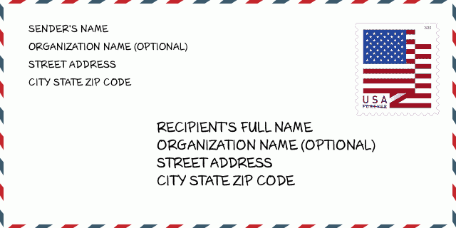
نشانی مثال
BLUE MOUND KS 66010-9403
UNITED STATES OF AMERICA
66010-9403 نمونه پاکت

-
این نمونه ای از پاکت نامه ایالات متحده است. اطلاعات فرستنده را در بالا سمت چپ و اطلاعات گیرنده را در پایین سمت راست وارد کنید. اطلاعات لازم نام کامل فرستنده/گیرنده ، آدرس خیابان ، شهر ، ایالت و کد پستی است. اطلاعات آدرس گیرنده برای مرجع شما داده شده است. به طور کلی ، اگر از کد پستی کامل 9 رقمی مطمئن نیستید ، فقط می توانید کد پستی 5 رقمی را پر کنید تا از دست دادن بسته جلوگیری شود.
66010-9403 معنای اساسی
-
هر رقم کد پستی 66010-9403 مخفف چیست؟ کد ZIP+4 از دو بخش تشکیل شده است، پنج رقم اول را می توان در اداره پست قرار داد، و چهار رقم آخر می تواند یک بخش جغرافیایی را در منطقه تحویل پنج رقمی مشخص کند. 6-7 رقم بخش یا چند بلوک را مشخص می کند و رقم 8-9 نشان دهنده بخش یا یک طرف خیابان است.
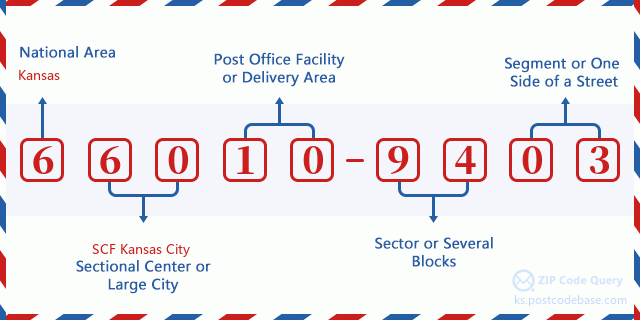

- ·شناسایی مسیر حامل?
A 4-digit code assigned to a mail delivery or collection route within a 5-digit ZIP Code. The first character of this identification is alphabetical, and the last three are numeric: Bnnn = PO box Hnnn = Highway contract Rnnn = Rural route Cnnn = City delivery Gnnn = General delivery: R091 (مسیر روستایی)
- ·بخش پایین افزونه فشرده?
The ZIP Add-On Low Sector and the ZIP Add-On Low Segment together form the ZIP Add-On Low Number. The ZIP Add-On Low Number is the last four positions of a ZIP+4 code; the low-end ZIP add-on in a range of codes; the add-on of the first ZIP+4 code in a consecutive series of ZIP+4 codes assigned to the delivery address. For example, most delivery addresses are assigned a single ZIP+4 code. However, large companies may be given a range of ZIP+4 codes that can be used to route mail to specific departments. A range of ZIP+4 codes can also be assigned to a corresponding range of post office boxes, and each box is mapped, one-to-one, with a ZIP+4 code in the range. A single post office box can also be assigned a range of ZIP+4 codes.: 94
- ·بخش پایین افزونه فشرده?
The ZIP Add-On Low Sector and the ZIP Add-On Low Segment together form the ZIP Add-On Low Number. The ZIP Add-On Low Number is the last four positions of a ZIP+4 code; the low-end ZIP add-on in a range of codes; the add-on of the first ZIP+4 code in a consecutive series of ZIP+4 codes assigned to the delivery address. For example, most delivery addresses are assigned a single ZIP+4 code. However, large companies may be given a range of ZIP+4 codes that can be used to route mail to specific departments. A range of ZIP+4 codes can also be assigned to a corresponding range of post office boxes, and each box is mapped, one-to-one, with a ZIP+4 code in the range. A single post office box can also be assigned a range of ZIP+4 codes.: 03
- ·بخش بالا افزونه فشرده?
The ZIP Add-On High Sector and the ZIP Add-On High Segment together form the ZIP Add-On High Number, which is the high-end ZIP add-on in a range of codes; the add-on of the last ZIP+4 code in a consecutive series of ZIP+4 codes assigned to the delivery address. Most delivery addresses are assigned a single ZIP+4 code; however, large companies may be given a range of ZIP+4 codes that can be used to route mail to specific departments. A range of ZIP+4 codes can also be assigned to a corresponding range of post office boxes, and each box is mapped, one-to-one, with a ZIP+4 code in the range. A single post office box can also be assigned a range of ZIP+4 codes. (See also ZIP Add-On Code.): 94
- ·بخش بالا افزونه فشرده?
The ZIP Add-On High Sector and the ZIP Add-On High Segment together form the ZIP Add-On High Number, which is the high-end ZIP add-on in a range of codes; the add-on of the last ZIP+4 code in a consecutive series of ZIP+4 codes assigned to the delivery address. Most delivery addresses are assigned a single ZIP+4 code; however, large companies may be given a range of ZIP+4 codes that can be used to route mail to specific departments. A range of ZIP+4 codes can also be assigned to a corresponding range of post office boxes, and each box is mapped, one-to-one, with a ZIP+4 code in the range. A single post office box can also be assigned a range of ZIP+4 codes. (See also ZIP Add-On Code.): 03
- ·کد پستی افزونه: 9403
- ·محدوده?
The range of +4 codes. Summing the +4 Code and the +4 Range will give you the high end of the range of +4 Codes that pertain to this ZIP Code.: 0
- ·کد متناوب پایه?
Code that specifies whether a record is a base (preferred) or alternate record. Base records (represented as "B") can represent a range of addresses or an individual address, such as a firm record, while alternate records (represented as "A") are individual delivery points. Government deliveries will only be listed on alternate records with the appropriate government building indicator (federal, state, or city) set.: پایه
- ·شماره مالی?
A code assigned to Postal Service facilities (primarily post offices) to collect cost and statistical data and compile revenue and expense data. The state number comprises the first two positions of the finance number.: 191144
- ·شماره ناحیه کنگره?
A standard value identifying a geographic area within the United States served by a member of the US House of Representatives or Senate. If Army/Air Force (APO) or fleet post office (FPO), this column will be blank. If there is only one member of Congress within a state, the code will be "AL" (at large).: 02
- ·کلید دولتی خط نهایی ترجیحی?
An index to the City State file that provides the preferred last-line name for this address range.: W20183
نقشه آنلاین

این نقشه آنلاین آدرس 1900 COUNTY RD 1077 BLUE MOUND است. برای حرکت و زوم میتوانید از دکمه استفاده کنید. اطلاعات نقشه تنها برای مرجع است.
نشانی: 1900 (From 1900 To 1999) COUNTY RD 1077, BLUE MOUND, KS 66010-9403, USA
دیدگاه


افزودن دیدگاه جدید